
In his 2022 speculative documentary on Netflix, Ancient Apocalypse, Graham Hancock spends most of one episode talking about Gunung Padang. And gets most of it wrong.
Because most of the work done in relation to Gunung Padang is published in Indonesian if it’s even possible to obtain, there is little for the average, non-specialist consumer of archaeological news to search for if they want to apply critical thinking or just seek the views of trained specialists over those of pseudoscience. Even the Wikipedia article on the site is limited in data.
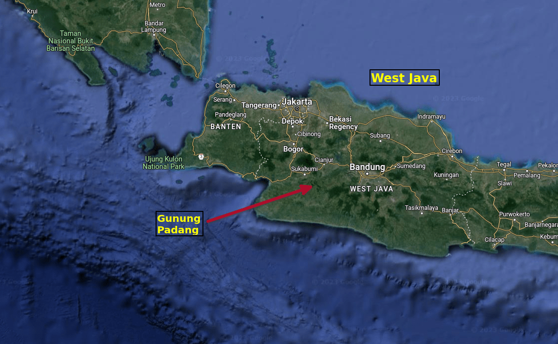
Gunung Padang is a site of monumental architecture built in a series of five terraces at the top of a small volcanic mountain or hill. It was originally described as early as 1915 by N.J. Krom in Rapporten van den Oudeheidkundinge Dienst in Nederlandsch-Indie (Krom 1915: 54).
In that report, Gunung Padang was described as having four terraces connected by steps of rough stone and containing tombs, though this latter conclusion was offered with a question mark. In the years since, no interments, graves, or human remains have been discovered associated with the site’s features.
Gunung Padang was rediscovered in 1979 by 3 locals (Endi, Soma, and Abidin) who were farming on the hill and noticed a high wall and the arranged stonework. They reported the find to Indonesian officials and in the 1980s the site was investigated and some restoration work done. By 1998, Gunung Padang was declared a heritage site and, in 2014, it was elevated to a national cultural site by the Indonesian government following the sensationalist interpretations of Danny Hilman Natawidjaja and other purveyors of pseudoscience.

In 2018, Natawidjaja, along with four co-authors, presented a poster at the American Geophysical Union conference in Washington DC (Natawidjaja et al 2018). This poster outlined several survey methods he and his colleagues used to obtain data from which they concluded Gunung Padang is a man-made structure and the “world’s oldest pyramid,” dating to as early as 28,000 BP.
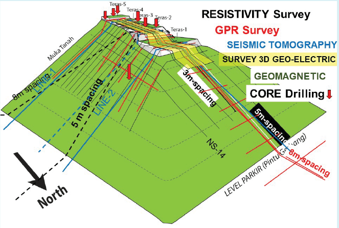
They cored bore-holes to obtain samples for radiocarbon dates, used Ground Penetrating Radar (GPR), Electric Resistivity Tomography (ERT), Seismic Tomography, and excavated trenches.
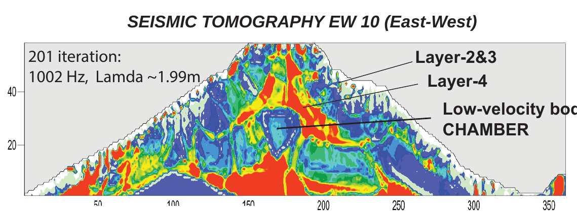
The data they showed on their poster makes sense. In fact, it’s exactly what one should expect from an extinct, collapsed, basaltic stratovolcano in Indonesia. Excavations revealed numerous columnar joints, and tomography from the geophysics work revealed alternating layers of dense and light stratigraphy along with potential voids.
But, where Natawidjaja and his colleagues interpret them to be cultural, no evidence actually supports this.
None of the radiocarbon dates were from cultural material. Their own data (see the table below) shows that they dated “soil.” Not a single cultural artifact or feature was retrieved.
Radiocarbon Table for Soils at GP
| Sample # | BETA # | Site | Sample Type | Layer | Conventional 14C | Calibrated 14C | % Mod Carbon |
|---|---|---|---|---|---|---|---|
| GP1-295 | 331493 | CoreDrilling #1 | Soils | Near Surface | 560 +/- 30 BP | 520 - 540 BP | 93.3 |
| GP1-1115 | 331494 | CoreDrilling #1 | Soil b/w rocks | Layer 2 | 13510 +/- 50 BP | 16640 - 16790 BP | 18.6 |
| GP2-390 | 331495 | CoreDrilling #1 | Filled Soil | Buring Layer 3 | 8710 +/- 40 BP | 9550 - 9770 BP | 33.8 |
| GP2-750 | 331496 | CoreDrilling #2 | Soil b/w rocks | Layer 3 | 22750 +/- 120 BP | 26990 - 27870 BP | 5.9 |
| GP2-1130 | 331498 | CoreDrilling #2 | Soil b/w rocks | Layer 3 | 19400 +/- 80 BP | 22970 - 23410 BP | 8.9 |
| FC5 | 423691 | Trenching Fanta | Soils | Near Surface | 480 +/- 30 BP | 539 - 589 BP | 94.2 |
| ES1 | 423690 | Trenching Echo2 | Soil b/w rocks | Layer 2 | 7400 +/- 30 BP | 8129 - 8339 BP | 39.8 |
| EM4 | 423689 | Trenching Echo2 | Soil b/w rocks | Layer 1 | 3630 +/- 30 BP | 3899 - 4039 BP | 63.6 |
| GP1-500 | BATAN-INA | CoreDrilling #1 | Gravely Soils | underlying Layer 2 | 6700 +/- 70 BP | 7522 - 7735 BP | 45.2 |
| Charlie-3 | BATAN-INA | Charlie-1 | Soil b/w rocks | Layer 1 | 3025 +/- 30 BP | 3206-3405 BP | 69.4 |
| Charlie-4 | BATAN-INA | Charlie-1 | Soil b/w rocks | Layer 1 | 3630 +/- 40 BP | 3903 - 4072 BP | 64.5 |
| Charlie-5 | BATAN-INA | Charlie-1 | Soil b/w rocks | Layer 2 | 7095 +/- 60 BP | 7857 - 8079 BP | 42.4 |
The voids are very consistent with lava tubes and magma chambers or pockets of air created during the collapse of the caldera. Java and the rest of Indonesia are rife with caves, both karst and volcanic. There is every reason to expect small to large voids in this type of extinct volcano.
Their insistence that the hill was “constructed” just doesn’t make sense. Particularly given the sheer amount of columnar jointing found associated with volcanic activity. This sort of rock formation is created when lava cools and it continues to extrude from the central magma chamber, either through vertical or near vertical shafts or even horizontal ones.
Geologists looking at volcanoes in the vicinity, including Gunung Padang, describe the hill as being the youngest plug of andesitic basalt lava with columnar structure in the crater of an ancient volcano called Karyamukti (Bronto & Herman 2012; Bronto 2015; Bronto & Langi 2016). This volcano would have been active until around 32 million years ago.
In more recent years (probably 500 BCE-500 CE), people collected the columnar basalt and stacked it on the hill to form a terraced site of monumental architecture known as a punden berundak.
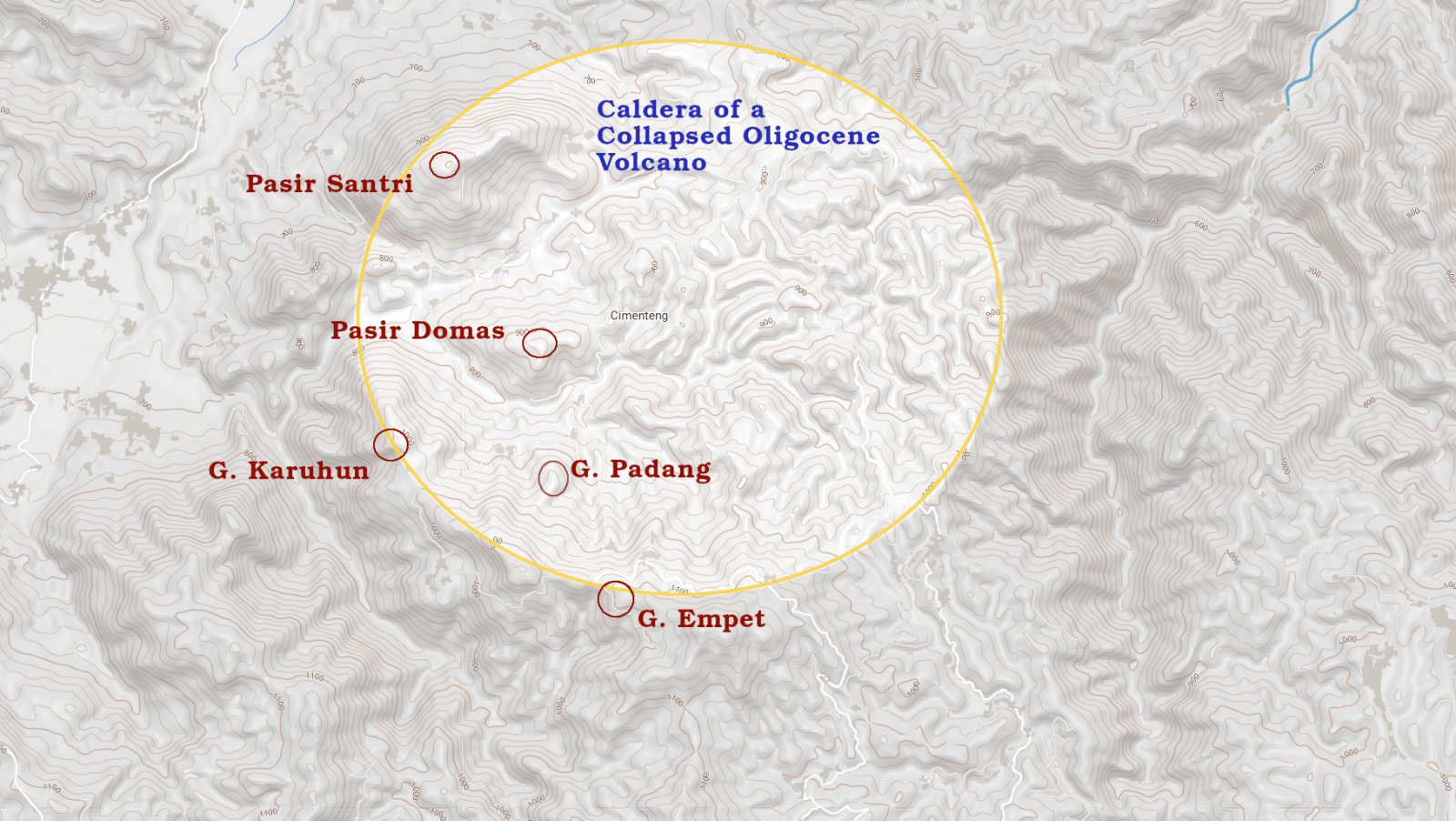
It should be noted that while the relatively small hill of Gunung Padang (Mount Padang) is volcanic in origin, it probably isn’t the primary cone of the extinct volcano it originated from. This was a much larger volcano that was active in the Oligocene (32 ma as mentioned above). Referred to as the Karyamukti volcano by the geologists and volcanologists who studied the region, this volcano eroded and collapsed over millions of years, leaving behind some small hills with andesitic-basalt lacoliths and other features in the bedrock.
Gunung Padang sits inside the collapsed caldera of this Oligocene volcano. At the edge of the caldera to the south and west is the crescent shaped Gunung Empet. To the west is Gunung Karuhun. On the northwest edge of the caldera is Pasir Santri with Pasir Domas between it and Gunung Padang.
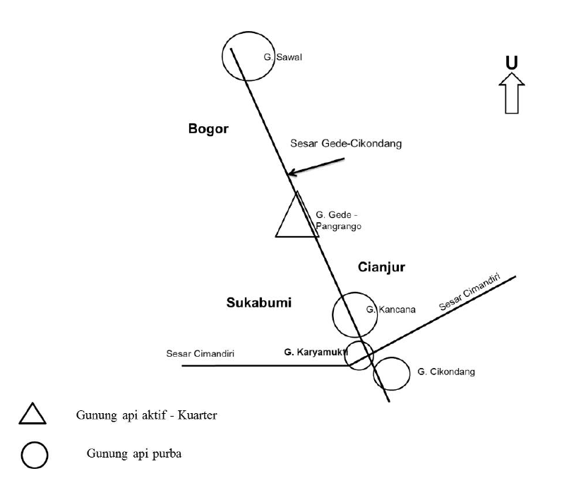
When you zoom out and view the region from a grand scale, Gunung Padang resides at the intersection of the Cimandiri Fault and the Gede-Cikondang Fault. The latter is formed by the alignment of several extinct volcanoes and one active. The Sawal, Gede-Pangrango, Kancana, and Cikondang volcanoes create a northwest-southeast line.
Orthogonal to the Gede-Cikondang Fault is the Cimandiri Fault, which runs southwest-northeast.
And, at the intersection of these two fault lines is the extinct Karyamukti volcano with Gunung Padang nestled within.
In addition to Natawidjaja’s pseudoarchaeological claims, there are quite a few other wild and wholly unsubstantiated claims made about the site:
- That the basalt/andesite columns were carved on location.
- That the basalt/andesite columns were harvested from distant quarries.
- That the basalt/andesite columns were geopolymers poured into molds.
- That the site is home to a massive, electromagnetic “vortex” (whatever that is).
- This was a colony of Atlantis or otherwise connected to Atlantis.
- Before it was inundated 12,000 years ago, Sundaland was home to an “advanced civilization” and they developed the world’s pyramid-building skills.
Among the pseudoscience folks, there might be some disagreement with some of these bullets, but they nearly universally agree that Gunung Padang is a man-made pyramid with one or more secret chambers or tombs within, and that this pyramid is between 20,000 and 28,000 years old.
In spite of the real science that Natawidjaja and his colleagues did at the site, they are still wrong about most of what they concluded. This isn’t necessarily because they used bad methods (which some Indonesian archaeologists are actually saying of them), rather it’s because they probably arrived at the site with a conclusion: that this was an entirely man-made site. One that Indonesia can be proud of!
Unfortunately, the conclusion they began with clouded their ability to see anything in the results but what they wanted.
The geophysical prospection with GPR and ERT showed anomalies. Some parts of the data are consistent with voids or spaces. The low velocity reflections in the seismic tomography were supported by the high resistivity of the ERT. Both of these were consistent with voids or spaces underground at depths that appeared to be around 15-30 meters. Natawidjaja’s conclusion: “hidden tunnel/chamber;” therefore, the oldest pyramid in the world.
Except, the geophys work is also consistent with the sorts of voids and natural chambers associated with the remnants of a once large volcano that has, over millions of years, collapsed, eroded, and slumped with seismic events.
The bore holes produced soil samples that were radiocarbon dated. Consistent with strata that have undergone significant seismic events in the last 20,000 years.
and alleged to be a 52,000 year old
“amulet.”
None of the data Natawidjaja and his colleagues produced shows any indication of cultural occupation prior to the periods expected, which is roughly 45 BCE – 22 CE at the earliest.
Could their methods just be bad?
So far, I’ve described the work by Natawidjaja et al as if they did good work and simply arrived at bad conclusions. But there is some indication that their work is shoddy too.
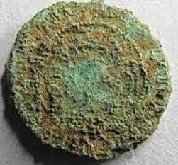
They apparently found a coin, which they prefer to call an “amulet,” in a layer that they’ve dated to over 7,000 years BP. The problem is, this is a coin minted between 1914 and 1945. The stark similarity between the alleged “amulet” and the modern coin image has not dissuaded Natawidjaja et al in the least. They conclude it’s not a coin from a little over 100 years ago, rather an amulet of perhaps 5200 BCE. Why so similar? Because the Dutch modeled their coins after ancient amulets, silly.
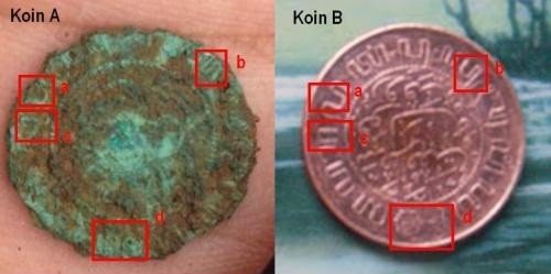
condition of the issued period (1914-1945)
You may have noticed I’ve accused Natawidjaja and others of arriving at Gunung Padang with a conclusion to which they seek only those data that fit. The coin above is an example of forcing a round object of a reality into the square hole of expectation. And to underscore Danny Hilman Natawidjaja’s expectations about the world, we have to look no further than his 2013 book Plato Never Lied: Atlantis is in Indonesia.
There’s an entire Atlantis sub-genre that focuses on how Plato’s allegorical tale was a reality in Southeast Asia and the Austronesian islands. Rebecca Bradley does a wonderful job summarizing this on her blog The Lateral Truth, specifically in her article, “Gunung Padang: Last Open Letter to Danny Hilman.” I highly recommend this two-part series, which links to another article series she wrote about Gunung Padang.
In short, Gunung Padang is an absolutely wonderful site and it may possibly be one of the earliest known examples of a punden berundak, a stepped or terraced temple for worship of ancestors in Austronesia. It’s true significance is clouded by the pseudoarchaeological approach of a legitimate geologist and his colleagues who are afflicted by one or both of two problematic biases: 1) a belief that Atlantis was a genuine advanced culture in existence prior to 12,800 years ago; 2) a nationalist desire to elevate this and other sites as a point of nationalist pride.
This latter topic is one I didn’t go into here, but it’s one you can read about at this link or within one or two of the references I list below.
Just keep in mind when you see Gunung Padang mentioned on social media or in speculative documentaries—speculamentaries if you will—this is a very cool site in its own right: very cool geology and very cool cultural occupation. It doesn’t have to be the biggest or oldest of anything be so. No evidence so far shows it to be any older than about 45 or 50 BCE, which is about 2,000 years BP.
Some Thanks
Thanks to Paul Heinrich, who’s work I’ve been reading for years going back to the days of UseNet. The papers you sent were just the rabbit holes to get me started!
Thanks also to a few donors that kept me in coffee while typed several non-OCR Indonesian papers into Google Translate to create English versions. I’m humbled by your generosity and it definitely motivates me to write more.
Further Reading and Bibliography
Auliani, Palupi Annisa (2013). The Megalithic Polemic Still Continues. National Geographic Indonesia.
Bellwood, Peter (2017): First islanders. Prehistory and human migration in Island Southeast Asia, Wiley Blackwell, Hoboken.
Bradley, Rebecca (2016): “Pyramids Pt.3: Radiocarbon at Gunung Padang”, The Lateral Truth, Skeptic
Ink.
Bronto, Sutikno and Danny Z. Herman (2012). Geology of Mount Padang and Surrounding Area, Cianjur District—West Java. Yogyakarta 2012 PIT IAGI Proceedings, The 41st IAGI Convention and Exhibition.
Bronto, Sutikno and Billy S. Langi (2016). Geology of Mount Padang and Surrounding Area, Cianjur District -West Java. Journal of Geology and Mineral Resources, 17(1).
Bronto, Sutikno (2015). Gunung Padang Dan Sekitarnya Dipandang Secara Geologis (Mount Padang and its surroundings are viewed geologically). Paper presented at the Borobudur Writers and Cultural Festival 2015, 12-14 November 2015, Borobudur, Magelang Regency, Central Java.
Budkewitsch, Paul and Pierre-Yves Robin (1994). Modeling the evolution of columnar joints. Journal of Volcanology and Geothermal Research, 59, 219-239.
García, Victor Lluís Pérez, (2017). Gunung Padang y el megalitismo indo-malayo: Arqueología y pseudoarqueología. Arqueoweb, 18(1), 62-104.
Idris, Nadia Absharina, A. P. Maharoni, M. T. Nur Fauzi, and I.P.W.T. Brunner (2013). Correlation between Gunung Padang and Sundanese Traditional Roof. Online Journal for the National Institute of Technology, 3(1), 1-9.
Irwanto, Dhani (2015): Atlantis. The lost city is in Java Sea, Indonesia Hydro Media, Bogor.
Krom, NJ (1915): Rapporten van den Oudheidkundinge Dienst in Nederlandsch-Indie 1914. Published by the Batavian Society of Arts and Sciences. Albrecht & Co. Batavia. M. Nijhoff. The Hague.
McKinnon, E. Edwards (2018). “Archaeology and Cultural Heritage Management: A Personal Review, 1970-2011.” In, Eric Tagiacozzo (Ed.), Producing Indonesia: The State of the Field of Indonesian Studies. Cornell Southeast Asia Program Publications, Ithaca, NY.
Natawidjaja, Danny Hilman (2013a): Plate never lied. Atlantis is in Indonesia, Booknesia, Jakarta.
Natawidjaja, Danny Hilman (2013b): “The Prehistoric Cultures, Are They Primitive? Case Study from Gunung Padang megalithic sites, West Java, Indonesia”, Paper presented at The World Culture Forum Seminar, 26 November 2013, Bali.
Natawidjaja, Danny Hilman, Andang Bachtiar, Bagus Endar, Andri Subandrio, and Mudrik Daryono (2018). “Evidences of large pyramid-like structure predating 10,000 Year BP at Mount Padang, West Java, Indonesia: Applications of geological-geophysical methods to explore buried man-made structures.” Poster presented at the Fall Meeting of the AGU, 10-14 December.
Yondi, Lofti (2012). The terraced punden of Gunung Padang is a masterpiece of the ancestors and it contains the values of environmental wisdom in the Sundanese past. Bandung Institute of Archeology research report, pp. 1-16.
If archeologists didn’t do the hard work what would the Hancocks of the world have to cherry-pick & lie about?
Dear Carl,
I told you in the Facebook group.
It’s not “speculamentaries,” it’s “crockumentaries.