I found myself somewhat amused by Brien Foerster’s video that highlights a few moments of a tour he guided in Luxor, Egypt at the Temple of Karnak. By the end, I felt very bad for the people that gave him their money for the tour, expecting an educated experience.
Here’s the video:
The bold, italicized passages are transcripted from the video for discussion here and have time stamps at the beginning.
0:28 “This was originally a single piece of travertine stone and it’s unlikely that the quarry is in Egypt it could be as far away as Turkey.”
Travertine rock was quarried from many places in the Nile Valley such as Hatnub and Mallawi. There is no good reason to go through the expenditure of time and effort to move large stones from outside the Nile Valley or Egypt. “Travertine” is a term used to describe carbonate rocks that are formed by mineral deposition from a solution. These are rocks like stalagmites, stalactites, or from cave walls and floors. They can also form in hot springs or from waters that percolate through carbonate strata like limestone.
That Foerster suggests Turkey as a source is beyond strange. But, as we’ll see, much of what Foerster suggests about Egypt has a similar strangeness.
2:40 “You look at the incredible straightness of this line unlikely that it could have been done by hand.”
Foerster doesn’t explain why, exactly, this is unlikely. He leaves this to the viewer’s imagination. Ostensibly, it was beyond the capability of a “primitive” society to obtain straight lines and then cut stone along them.
The stone itself is the “travertine” rock that Foerster mentioned above. The local name for it, which he conveniently avoids (perhaps because clashes with his out of Turkey narrative) is “Egyptian alabaster.” Unlike a genuine alabaster, this stone is completely devoid of gypsum and is mostly calcite. The most significant quarries for this soft stone were near Akronis, which is near modern Tahna Al Jabal in Middle Egypt about 500 km away, but much closer than Turkey! There were probably some much closer sources for it as well.
This stone is soft and easily cut compared to other stone they were working with. Smooth, straight lines are not difficult to obtain: pulling a string tight gives a straight line.
3:12 “And here you see a saw cut in Granite likely an ancient power saw. And look at the precision of all of these surfaces this groove looks like it was done by a power router.”
With this statement, Foerster passes ridiculous and enters a realm of complete and utter disinformation and falsehood. Is it to sell more tours, books, and DVDs? Does fabricating a mystery out of whole cloth make it easy on his bottom line?
Whatever the answer, Foerster clearly has a poor understanding of terms such as”likely” as he states that the cut was “likely an ancient power saw.”
The Egyptians had a variety of methods for cutting granite. None of them involved “power saws” in the way Foerster intends. For such a thing to be “likely,” there would need to be whole categories of assumptions fulfilled, not the least of which would be how did they harness electricity and distribute it and why aren’t these “power tools” and the hardware that generates the power represented in the archaeological record? Not just as artifacts and features themselves, but also textually reflected. The Egyptians wrote down a lot of things!

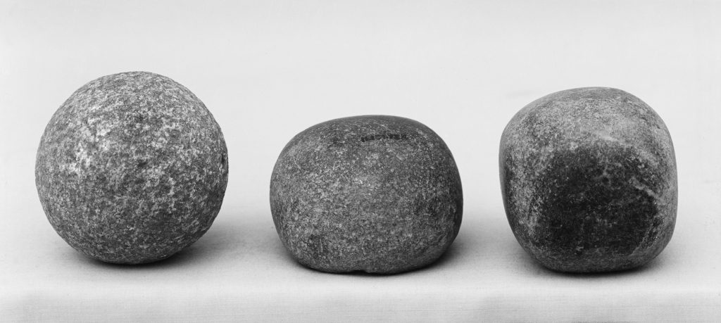
One method among several would easily explain his “power router” claim. The use of dolerite balls allowed a single worker to remove about 12 cm^3 of granite material per minute. In a year, this would work out to about 1.8 m^3 (8 hours/day for 300 days). The unfinished obelisk at Aswan, for which there is a termination groove that would fit a dolorite ball very easily, would have taken 130 workers less than 1 year. Or nearly half the time if the work was done in shifts [1].
4:16 “This is supposed to be the east-west line but it’s 23 and a half degrees off of true east and west this gives us evidence that the original causeway here was constructed 12,000 years ago prior to the earth having its present axis of 23 and a half degrees.”
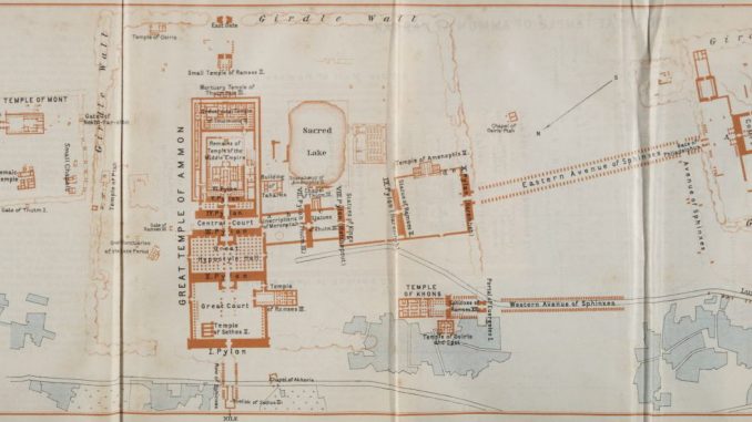
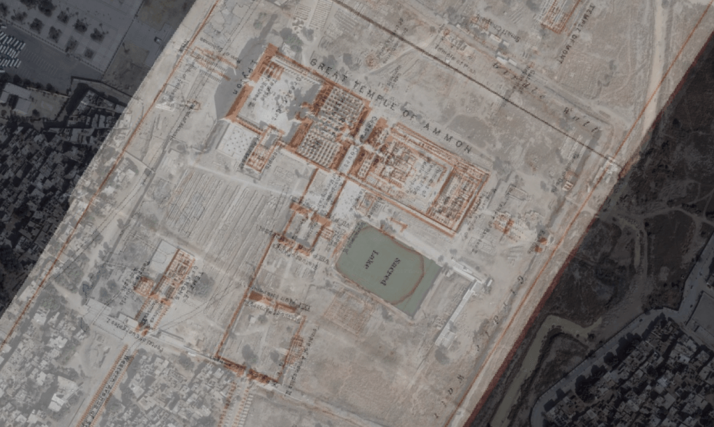
One can only think that Foerster is referring to Precession, the process by which the Earth’s axis wobbles a bit (23.4 degrees) over the course of 26,000 years. It’s certainly true that there is a causeway that is often called the “east-west,” which heads from the inner temple toward the Nile in the west. The causeway that heads toward the palace of Mut is often called the “north-south.” But both of these are roughly southeast-northwest and northeast-southwest causeways, respectively. Referring to one as east-west is just simpler.
The thing to keep in mind with the temple complex at Karnak is that it was built in stages and at different periods. Senusret I built the initial temple during the Middle Kingdom (1971-1926 BCE) probably with a rectangular peristyle court and a series of inner chambers accessed from a central axis. Over time, several rulers added additional features like pylons, chapels, walls, obelisks, sphinxes, and so on.

So the placement of the “east-west” causeway was probably with an intention to face the Nile river more than being precisely facing the west. In fact, it almost certainly was built with the position of the Nile in mind. And the Nile would have been much closer than the current half a kilometer or so it is now. There may even have been a branch of the Nile that ran past the east side of the temple.
So what’s Foerster going on about with the “evidence that the original causeway here was constructed 12,000 years ago…?”
The causeway itself is roughly a bearing of 300 degrees on the compass, probably depending on where you stand and where you sight the compass. This is fairly close to 293.5 degrees, which would be 23.5 more than the 270 degrees of true, polar west. It’s close enough I’ll call Foerster right on this.
However–and this is a big however–he’s wrong about it being evidence for 12,000 year old construction. Among the many relative and absolute dating methods used in and around Karnak that also demonstrate him wrong, Foerster is also wrong because of the way he apparently thinks axial precession works.
Foerster’s apparent logic is that since the causeway is off the true west axis by about 23.5 degrees (more like 30 degrees, but lets give it to him), that this is because it was last aligned perfectly to true west 12,000 years ago when the axial tilt of the planet aligned with a different star for polar north.
There’s two things wrong with this assumption:
1) The star he’s thinking of is Vega and it was 12,000 BCE that it was our “north” star the way Polaris is today. So he’s probably crossing his wires on this, thinking 12,000 BP instead of 12,000 BCE. (By the way, around the time the first temple at Karnak was constructed, the star that would have been the north star was Kochab, though it was much dimmer than today’s Polaris).
2) That ain’t the way axial precession works. True north (or true west, east, or south) doesn’t change with the movement of the axial precession. Nor do the solstices change (on the off chance he tries to say it’s because the causeway is aligned to a solstice). The Earth is always at a tilt of 23.5 degrees. And polar north is always polar north no matter what star the axis is pointing at. Our directions on the Earth’s surface are, after all, pointing at the axis.
It would be like saying that the driver’s side mirror of your car changes location relative to you as the driver as you go around a curve in the road. This doesn’t happen. Unless you move your seat forward or backward, that mirror is always in the same spot to your left.
4:41 “… and down and here you see incredible weathering patterns that are not simply from wind and sand but could have been scorching heat as the result of plasma ejection from the Sun”
Plasma ejection from the sun. There you have it, folks. The crazy just got crazier. In the video, the “scorching” he points out look very much like the patina that develops from millions of people touching stone and leaving the oily residue from their sweaty hands (Egypt can be hot!) behind. It was a bit telling that all the “scorching” appeared to be right around pedestrian height. Though, to be honest, some of it was hard to see in the video.
I’m reasonably sure any “plasma ejection” from the sun significant enough to scorch stones in Luxor would be noticed in the geologic and archaeological records in a way that was a little more obvious.
I’m also reasonably sure by this point in his video, that Foerster will say just about anything if he thinks it will convince gullible people to spend their hard-earned cash on his tours, books, and dvds.
The rest of the video was repetitive and much the same stuff as above. Strangely enough, several of his tour group were sticking their noses in corners of chapels and such. It was extremely odd behavior and I’m sure a sight to see if you stumbled upon them during your family vacation.
I can hear the kids now: “Mommy, why is that lady standing in the corner? Was she bad?”
Further Reading and Notes:
- Klemm, Dietrich; Klemm, Rosemarie (2001). The building stones of ancient Egypt–a gift of its geology. African Earth Sciences, 33, 641-642.
Jesus – why work as an archaeologist when you can make a living talking shite?
Awww… you’re just saying that. You could prove it’s true by dropping a small tip in the donation box on the right 🙂