
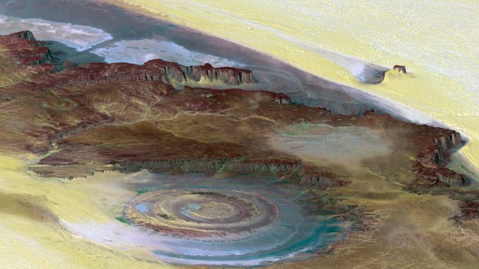
So is the Richat Structure the original location of Atlantis? The answer to that question, of course, is no. But there are many under-informed and click-baiting videos and social media posts trying to make that connection.
What and Where is the Richat Structure?
The Richat Structure, also called the “Eye of Africa” or “Guelb er Richat,” is a geologic feature in the Adrar region of the Sahara Desert in northern Mauritania. Measuring at least 40 kilometers (~25 miles) in diameter, this geological feature can actually be seen from space and was a prominent landmark for space crews of the early Gemini missions. From above, it has 3 concentric and circular ridges with a topographical depression at its center.
Early researchers hypothesized that the feature was an impact crater, which seems logical enough at first glance. However, geological surveys of the feature revealed it to be formed by a subsurface alkaline igneous intrusion that deformed the rock layers above as it uplifted and displaced them. The concentric rings are composed of gabbroic ring dikes and extrusive rhyolitic centers and comprise the remnants of an ancient volcanic maar system. The entire thing was created by a massive, low-temperature hydrothermal system about 98-99 million years ago in the mid-Cretaceous period.

geological details and stratigraphy. Image by Liu, X.-Y.; Li, A.-B.; Chen,
H.; Men, Y.-Q.; Huang, Y.-L, CC-BY: 4.0
Why the connection to Atlantis, Plato’s allegory?
The viral content of several prominent purveyors of fake, fantastic, and fraudulent archaeological claims have promoted the idea that the Richat Structure is the remnants of Atlantis due to its superficial physical resemblance to Plato’s description of the Atlantean capital’s concentric rings. A YouTube content creator and conspiracy theorist in 2018 was partly responsible for this cultural resonance—the viral nature—of the idea, though he was hardly the first to point it out. Still, this conspiracy theorist’s ideas were even picked up by several popular news outlets and pod-casters, firmly seating the link in public consciousness.
First, some context
A connection like this thrives mostly because of preexisting popular perceptions of mythical submerged lands that have been on the fringes of real archaeology since at least the 19th century. This fascination emerged in part because of a shift in how the public viewed ancient myths, perhaps driven by dramatic archaeological breakthroughs and the rise of esoteric literature.
Heinrich Schliemann successfully located Troy, Mycenae, and Tiryns and he was famous for believing that Homer’s Iliad and Virgil’s Aeneid were historical records rather than stories or fables. His spectacular success showed the world that ancient texts held geographic (and historic?) truths and this sparked a wave to locate other “lost worlds.” Like Atlantis.
At the same time, there was a rise in esoteric and outright pseudo-historic literature introducing the public to entirely new “lost continents” like Mu and Lemuria. The Theosophical Society, co-founded by Helena Blavatsky, became a central catalyst in popularizing myths surrounding lost worlds and sunken continents. In Isis Unveiled (1877) and The Secret Doctrine (1888), she brought these scattered ideas into a unified, pseudoscientific theory. One that established Lemurians, Atlanteans, and Aryans into what she called “root races” (the 3rd, 4th, and 5th respectively).
In the midst of her racist conjecture, American politician and populist reformer Ignatius Donnelly published Atlantis: The Antediluvian World (1882) and it became an instant bestseller. In it, Donnelly positioned Atlantis as the original “Garden of Eden” and thus the birthplace of all human civilization. When Atlantis was submerged in The Flood (yes, the Biblical one), survivors ended up all over the globe: Egypt, Mexico, Europe, Asia, etc, creating the cultures that emerged there.
Donnelly seems fairly ignorant of Blavatsky’s work—or maybe he just disagreed with her “esotericism” since he prided himself as being “scientific” and “rational.” But that didn’t stop Blavatsky from using his in The Secret Doctrine just a few years after Donnelly’s wild success. She even cited him as an authority, using his work to compare the spurious similarities between pyramids of Egypt and the Maya.
Okay, but what’s the connection to the Richat Structure?
Granted, neither Blavatsky or Donnelly knew anything about the Richat Structure all the way in Mauritania. Hell, no one really knew about it until photos from space started making the rounds in the 1960s. But they did create the very intellectual blueprint—that pseudoscientific vocabulary—and a global mythology that modern conspiracy theorists and pseudoarchaeologists use to justify it today.
Conspiracy theorist YouTube channels like Bright Insights and click-baiters on Twitter and social media like to claim Atlantis was destroyed about 11,600 years ago because of a cataclysm caused by an impactor during the Younger Dryas period. This, they say, triggered massive tsunamis across Africa, wiping out Atlantis. The roots of this idea can be found in another book by Donnelly, Ragnarok: The Age of Fire and Gravel (1883), since he was possibly the first to popularize the very fringe theory of “catastrophism.” His argument was that a rogue comet hit the Earth, changed the climate, and obliterated a lost, advanced civilization. Whether they know it or not, modern conspiracy theorists and purveyors of pseudoscience are just retelling an old myth.
Plato writes in Critias (~ 360 BCE) that Poseidon himself carved the capital city of Atlantis into “alternate zones of sea and land, larger and smaller, encircling one another […with] three rings of water and two rings of land.” When viewed from space, the Richat Structure’s bullseye appearance looks surprising like this description. And, admittedly, the Richat’s measurements are also very close to the 127 stadia (23.5 km) mentioned by Plato. Assuming you use the Attic stade (185 m) and not the Egyptian (157.5 m), the Olympic (192.3 m), the Delphi (177.5 m), the Ionic (210 m), the Greco-Roman (178 m), or the Persian (196 m).
Granted, there are a few reasons not to use some of these stadia and the Attic stade is the usual go-to for Plato-related stuff. But what about the very fuzzy target that is the actual edge of the Richat Structure itself. If I wanted to, I could point out the faintest, outermost rings effectively doubling the distance and the stade needed to make it fit Plato’s description would then be between 325-350 meters.
What’s this Younger Dryas Impact thingy?
There exists an hypothesis that the Younger Dryas—a period of relatively abrupt global cooling that happened about 12,900 – 11,700 years ago—was initiated by an impactor (either an asteroid or a comet). The scientific consensus is that changes in ocean currents triggered the freeze and, while “relatively abrupt,” it does not appear to be “catastrophic” in either the geological or archaeological records. The few papers that made it through peer-review were either retracted or have more holes than a colander. I wrote about the Younger Dryas Impact Hypothesis (YDIH) a few years ago and was admittedly on the fence leaning toward “not really a thing.” These days I’m firmly in that camp. There probably was no impactor that “ended civilizations” or sparked the YD period.
Salt in Corsetti’s Wounds
To support the mythical flood narrative, some conspiracy theorists have tried using the presence of surface-level salt in the Sahara to prove the region experienced a massive, catastrophic ocean flood. In fact, Jimmy Corsetti, of the Bright Insights YouTube channel seems to have made this the cornerstone of his “Richat-Structure=Atlantis” schtick. In a 2023 Joe Rogan podcast, he showed a satellite image of reflective patches he argued were salt. There and elsewhere, Corsetti states his belief that because salt is highly water soluble, it would have long ago been washed away or “burned up” by the volcano of the Richat Structure if it were millions of years old. Since it hasn’t, he claims it must be relatively recently deposited. Like 11,600 years ago. He also pairs this with the presence of marine fossils and gastropods in the region as additional proof of the “Flood.”
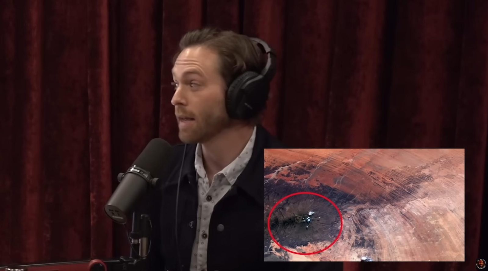
at the Richat Structure. Photo: screen grab from YouTube used in accordance with fair use.
Fundamentally, the salts in the Richat Structure, like the ones found within the sebkahs or salt flats, are linked to the surrounding bedrock. These are a set of sedimentary layers with ages ranging from the Late Proterozoic (800-500 Ma) to the Ordovician period (480-460 Ma). This is the source of the salt. Millions of years old. From 800+ to just 450 million years ago (Ma), the bedrock of the Richat Structure was being formed by shallow seas. They dried up, leaving behind evaporated salt and gypsum. A very similar process happened in places like modern day Texas in the Permian Basin (318-251 Ma).
So, over hundreds of millions of years, these ancient seas repeated a process of drying up and leaving behind deep layers of salt and gypsum within layers of limestone and sandstone. Then, around 100 Ma during the Cretaceous period, a magma intrusion pushed upward, doming the region and deforming the sediment layers. Nearly 100 million years of erosion by rain and wind continued to cut the surface, continually exposing the ancient salts. The rainwater and seasonal runoff from surrounding high points (ridges and bluffs) dissolved the salt out of the exposed bedrock. It ends up in solution, then rapidly precipitates out as an evaporate under the harsh Saharan sun, and is left in the salt flats for Corsetti to see in a satellite image.
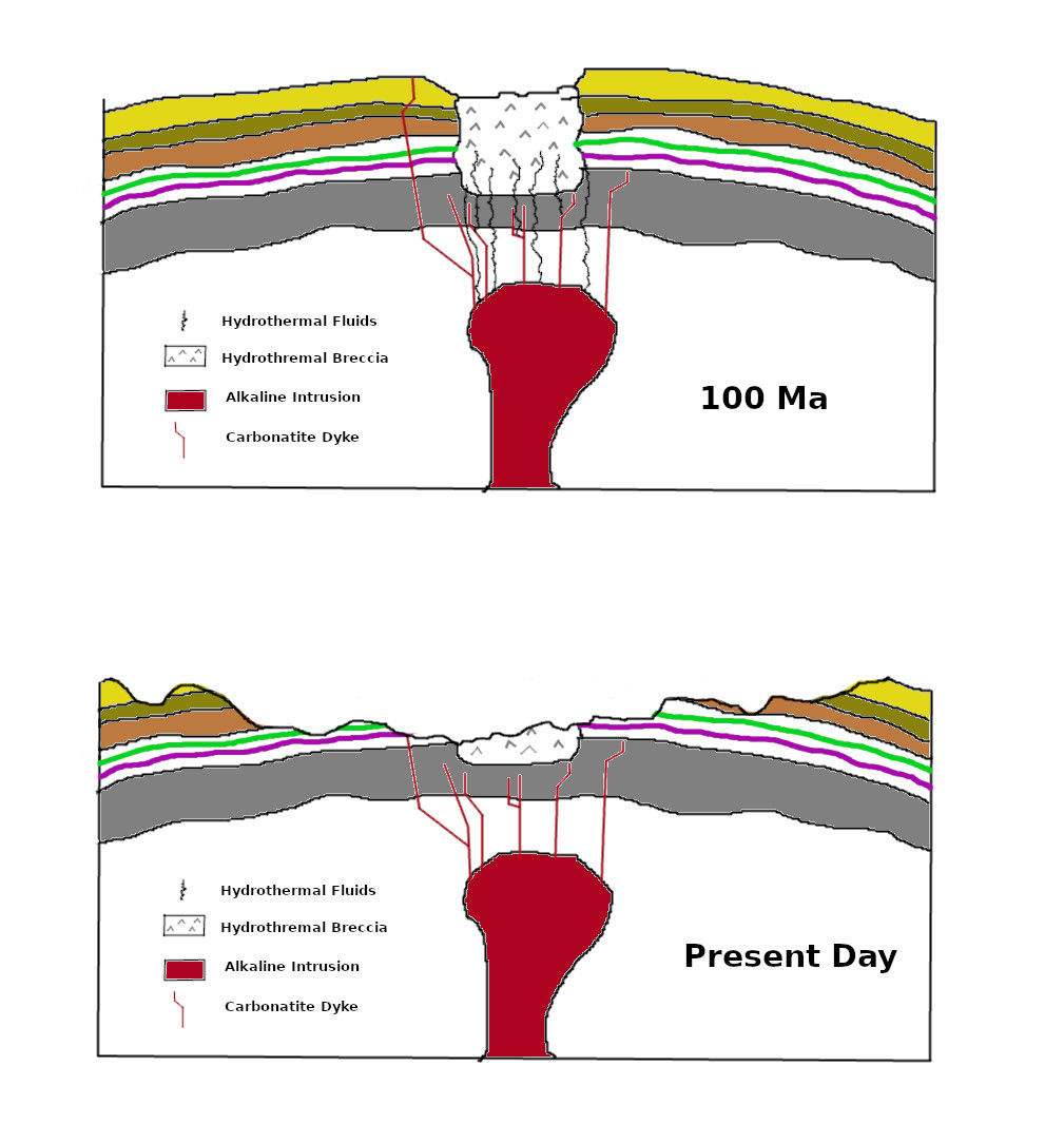
Simplified after fig. 9 in Abdeina et al. 2024.
Oh, and those “marine fossils” Corsetti leaned on as proof of a the “Flood” myth? Those are generally from the Paleozoic Era (500-300 Ma): brachiopods, stromatolites, and ancient mollusc fragments.
So what is known about the Richat Structure in Archaeological terms?
Archaeologically, there is a relatively rich history of study related to the Richat Structure and the region it resides in. Evidence of pre-Acheulean and Acheulean lithic industries around the Richat Structure was found as early as the 1930s, primarily driven by Théodore Monod. He discovered and described dense accumulations of “developed pebbles” used for chopping along with Acheulean bifaces all dated to the Lower Paleolithic. These were found in the outermost circular depression of the structure, mostly along the Oued Akerdil. Monod’s work in the area began to be noticed publicly around 1974 and inspired later multi-disciplinary investigations by French-Mauritanian teams who continued to research the region.
These multidisciplinary studies of the region showed that the prehistoric populations there made good use of the waterways near the outer ring where outcrops of quartzite were used to manufacture stone tools. The most prominent of the Acheulean sites with the largest tools were found along the northwest of the outer ring near two wadis (Oued Akerdil and Oued Bamouere). There are also Middle Stone Age Aterian tools dating to roughly 145,000–29,000 years ago and Neolithic spear points all found in the Richat Structure.
The outermost depressions of the Richat filled with water during the African Humid Period (~ 15,000-8,000 years ago) and is marked by a long-term human presence, evidenced by thousands of prehistoric stone burial mounds or tumuli of various styles along the naturally protruding dikes of land. Several rock art sites (Tililit, Oued Slil, Tin Labbe, and Lemqader) have also been mapped in the region, showing an ancient Sahara rich in fauna and human culture: elephants, giraffes, ostriches, bovids, horsemen, chariots, etc.
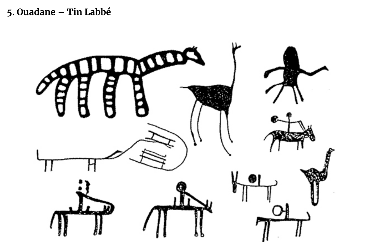
at the Richat Structure.
Why it almost certainly is not Atlantis
So, is the Richat Structure Atlantis? Of course not. Here are a few reasons why not.
- Atlantis was an allegory created by Plato to serve as a philosophical device. It was a way to discuss concepts of an ideal state and the dangers of imperial greed and hubris. He purposely named “Atlantis” as the greedy, corrupt state and Athens as the “good guy” in a political myth warning of the moral decay an inevitable downfall that comes with a society driven by materialism and military domination. He was essentially trying to save Athens.
- The story of Atlantis actually debunks itself. If we’re to accept as true the timeline Plato uses, and that Atlantis was a genuine city, then we cannot arbitrarily dismiss that Athens was also a thriving city 11,600 years ago. And yet, the archaeological record very clearly shows the region of Athens to be solidly in the Mesolithic period of culture at that time. That is, they were somewhere between Paleolithic hunter-gatherers and Pre-pottery Neolithic hunter-gatherers. Small nomadic groups, not yet farming, not yet creating pottery, living off the land. Not city folk.
- There was no ocean. Water didn’t fill between the rings. There are no artifacts of this alleged “advanced civilization”. There are no burials it. There are no material remains of any sort that show anything more than Neolithic hunter-gatherers near the outer rings for the time period Atlantis was supposed to be there.
- And, if we accept that the alleged tidal wave or tsunamis of the putative impactor (that also has no evidence) actually washed away every single trace of the city, why was it picky? Why did it ignore the fragile burials and sites with prehistoric people’s stone tools scattered about? Why were they impervious to tsunamis that left their artifacts in situ, but washed away the so-called “advanced” people living along side them?
Sources and Further Reading
Abdeina, E. H., et al. (2024). How old is the Eye of Africa? A polyphase history for the igneous Richat Structure, Mauritania. Lithos, 482–483, Article 107698. https://doi.org/10.1016/j.lithos.2024.107698
Barsky, D. (2019). North and Saharan Africa: Geography and culture during the Lower Stone Age. In C. Smith (Ed.), Encyclopedia of Global Archaeology. Springer Nature Switzerland. https://doi.org/10.1007/978-3-319-51726-1_2244-4
Clay, D. (2000). Plato’s Atlantis: The anatomy of a fiction. In J. J. Cleary & G. M. Gurtler (Eds.), Proceedings of the Boston Area Colloquium in Ancient Philosophy (Vol. 15, pp. 1–21). Brill.
Hoopes, John. W., Flint Dibble, & Carl T. Feagans (2023). Apocalypse not: Archaeologists respond to pseudoarchaeology. The SAA Archaeological Record, 23(3), 8–34.
Matton, G. (2008). Le complexe Crétacé du Richat (Mauritanie); un processus alcalin péri-Atlantique (Doctoral dissertation, Université du Québec à Montréal).
Matton, G., & Jébrak, M. (2014). The “eye of Africa” (Richat dome, Mauritania): An isolated Cretaceous alkaline-hydrothermal complex. Journal of African Earth Sciences, 97, 109–124. https://doi.org/10.1016/j.jafrearsci.2014.04.006
Matton, G., Jébrak, M., & Lee, J. K. W. (2005). Resolving the Richat enigma: Doming and hydrothermal karstification above an alkaline complex. Geology, 33(8), 665–668. https://doi.org/10.1130/G21542AR.1
Monod, T. (1975). Trois gisements de galets aménagés dans l’Adrar de Mauritanie. Provence Historique, 25(99), 87–97. https://doi.org/10.3406/prohi.1975.3345
Vernet, R. (2025). The Rock Climbs of the Adrar of Mauritania – III. Other Stations. Prehistory of the Western Sahara. https://prehistoireouestsaharienne.wordpress.com

It most certainly IS Atlantis otherwise how do you explain it being at the bottom of the ocean outside the Pillars of Hercules and surrounded by impassable mud shoals as Plato describes?/