
One of the first mentions of “ley lines,” if not THE first, was by Alfred Watkins in his book, Early British Trackways, Moats, Mounds, Camps, and Sites. In this book, written in 1922, Watkins notes that certain points of geographic or historic importance will line up. He said:
The facts I have discovered, which lead up to the conclusions, can be verified for the most part on an inch to mile ordnance map with aid of a straight edge.
Taking the earthworks mentioned [previously], add to them all ancient churches, all moats and ponds, all castles (even castle farms), all wayside crosses, all cross roads or junctions which bear a place name, all ancient stones bearing a name, all traditional trees (such as gospel oaks), marked on maps and all legendary wells. Make a small ring round each on a map. Stick a steel pin on the site of an undoubted sighting oint, place a straight edge against it, and move it round until several (not less than four) of the objects named and marked come exactly in line.
You will then find on that line fragments here and there of ancient roads and footpaths, also small bits of modern roads conforming to it. Extend the line into adjoining maps, and you will find new sighting points on it, and it will usually terminate at both ends in a natural hill or mountain peak, or sometimes (in the later examples) in a legendary well or other objective.
These three paragraphs are his “proof.”
While he’s clearly wrong (I’ll explain why in a moment), Watkins wasn’t out to find a supernatural or paranormal explanation for anything. He was legitimately trying to explain a pattern he noticed, which was that people seemed to follow patterns when it comes to where they build things. All in all, the hypothesis wasn’t crazy. He just figured if people used religious sites like Stonehenge and other cult sites of the Neolithic, they might have “roads” for making pilgrimages. The keep-it-simple-stupid principle would put them in a straight line.
The idea was flawed, however, and met with a fair amount of rebuttal in years to come: the routes didn’t take into consideration the natural landscape of cliffs, hills, rivers, marshes, bogs, and so on; also the sheer number of burial mounds and religious sites in the British Isles meant that coincidence was bound to happen. When the concept was considered statistically in Johnson (2009), the conclusion was, “the density of archaeological sites in the British landscape is so great that a line drawn through virtually anywhere will ‘clip’ a number of sites.”
Pseudoscience and the Paranormal Love Their Ley Lines
Because they’re esoteric. The idea is easy enough to claim by showing a map and some lines. The points on the map are indisputable. The lines are straight. Those that believe in the fantastic or push fake and fraudulent claims about archaeology and history love their ley lines.
The first use in this context was probably in John Michell’s The View Over Atlantis (1969), in which he claimed the people of Atlantis used places like Stonehenge and Avebury as “a great scientific instrument” which was “sprawled over the entire surface of the globe.” These sites, he suggested, were connected by mystical lines of energy–the very ley lines described by Watkins decades before. In fact Michell believed that Watkins “remained aware that there was a far deeper significance to the leylines than he had given mention to through the supposition of ancient trackways and trade routes.”
If that’s what Watkins believed, one is left to ponder how Michell knows this. Watkins certainly didn’t say it in writing that I’ve seen.
Michell, incidentally, is probably the first person to also use the term “megolithomania,” which is the term he used to describe that New Age, “Celtic Renaissance” that started somewhere around the mid-1960s and early-1970s. Suddenly white people in the west were embracing a mysticism they could call their own in a way they couldn’t legitimately do with Native American, African, Asian, or Australian mysticism (not that being white ever stopped some from appropriating the cultural and religious practices of others as their own mystical beliefs. Hell, even I bought the right-to-pour in a sweat ceremony from a Crow Indian back in the 90s.
The connection between those that subscribe to the megolithomania trend today, which is highly focused on large stone sites–many of which are natural but confused or insisted to be man-made–and ley lines is probably still strong. Today, the number of ley lines are limited only by the imaginations of those who believe them to be real concepts.
From Michell’s fanciful writings through to today, Ley Lines have become a wholly mystical concept, fully departed from Watkins’ original idea of trackways, pilgrimage roads, and trade routes.
They’re often described by New Agers, pseudoarchaeologists, and purveyors of the fantastic as “straight lines” that connect ancient and sacred places with “telluric energies.” Where two or more ley lines intersect, they are called “nodes” with the “power” of the sites increasing with the number of lines that intersect. This is from a document that popped up on a quick web-search which pointed to the “Galactic Channelings” website. I kid you not.
The document is “Project Ley Lines Update” and is dated 2014. But this is typical of the sort of definition you might see at any of these sorts of websites or within the pages of books marketed in the New Age and Mystical genre. This particular site claims ley lines are “driven by the sun:”
“A low elevation Sun, as seen at dawn and dusk, has a tendency to augment the size and energy carrying capacity of the ley line in comparison with its mid-day culmination. Hence the rising Sun is as such a powerful symbol and the dawn chorus is awakened long before our local star ascends the horizon.”
This sort of claim is more specialized and you get varied sorts of mystical, nonsensical claims that haven’t a rational basis when picked apart scientifically. But what “Galactic Channelings” had to say about ancient sites and the alleged ley lines is actually fairly typical:
“At such locations, we could expect to find places of worship and religious ritual such as temples, stone circles, henges and churches. We may also discover places of funerary and interment like sepulchres and barrow mounds. Such sites could also be fortified with earthworks or indeed, with a castle or moat indicating that something is certainly worth protecting. The presence of issuing water is highly suggestive of a ley line, especially a confluence of waters. Where there is a natural abundance of water, there is also a profusion of earth energies. Ley lines are also characterised by trackway junctions, milestones, standing stones, summit cairns and coastal headlands.”
Conveniently, the believer in ley lines ensures he or she has the highest amount of points on the landscape with which to plop down a relatively imprecise ruler (when compared with the scale on the map, one millimeter might be many kilometers!) and find ways to make straight lines.
A Critical Look at Ley Lines as a Concept
In order to accept that ley lines as described by most purveyors and believers in fantastic claims of antiquity or New Agers in general, there are some premises that have to be accepted as true:
1. These are straight lines that …
2. precisely intersect multiple points of …
3. sacred or important sites on the landscape (and, thus, not trivial points of little interest).
4. There is a genuine energy transmitted (sometimes claimed to be telluric)
5. That these ley lines existed first and the sacred sites were put on them
or
6. The sacred sites were built and the lines formed later because of them
So what happens when we examine these premises as claims?
#1
Let’s consider the first: that they lines are straight. When it comes to sites spread out on the surface of the Earth, how does one define “straight?” It is true, if you take a two-dimensional map on a piece of paper and spread it out on a table, you can easily draw a straight line from point A to point B with relative ease. One need only a straight edge or taught string to follow.
The problem is, however, that once you start to increase the distance of the line, “straight” becomes a very relative term. As Watkins originally described it, this was a line that followed the Earth’s surface from point to point. Much like a navigational meridian, which encircles the Earth, passing through each pole on its way until it arrives back at the point of origin. This line isn’t a line at all. It’s a circle (or, to be precise if not pedantic, an ellipse). However you decide to draw a ley line, if you make it long enough, it’s “straightness” becomes less and less apparent as it follows the curvature of the Earth.
So, can we now say the ley lines are not straight? If they were, then the line from one point to another of any appreciable distance away would burrow through the earth only to arrive at the next point from underneath at an angle less oblique the further away it is. So in order to pass through the maximum points (as the best ley lines apparently do) and offer the longest distance, we must, therefore, agree that ley lines aren’t straight.
#2
Okay, now what about the second premise? Ley lines precisely intersect multiple points?
I suppose this will depend on how you define precise and how wide a ley line is supposed to be. No where, not in any single reference by the proponents of ley lines, have I noticed where the width of these lines are defined. One would think a width would be a trivial bit of information given the ability for “the ancients” to detect them and all. But this is the sort of thing a ley line proponent would rather leave to the imaginations of the choir he or she is preaching to.
This is because if you spend too much time thinking about it, you realize that at some point the width can become so large as to render the concept meaningless. And at an opposite point they become so narrow as to be ineffective. And here’s why: when you draw a line on a map with a pencil wide enough to intersect each of the sacred sites along the alleged ley line, that line can be hundreds of meters across (if not several kilometers) depending on the scale of the map. On a 1:100,000 scale map, 1 millimeter on the map equals 100 meters on the ground. On a 1:24,000 resolution map, which covers a much smaller area, the same 1 millimeter equals 24 meters on the ground.
A popular ley line among believers is the St. Michael’s ley in England. In the map shown here, the line drawn is probably
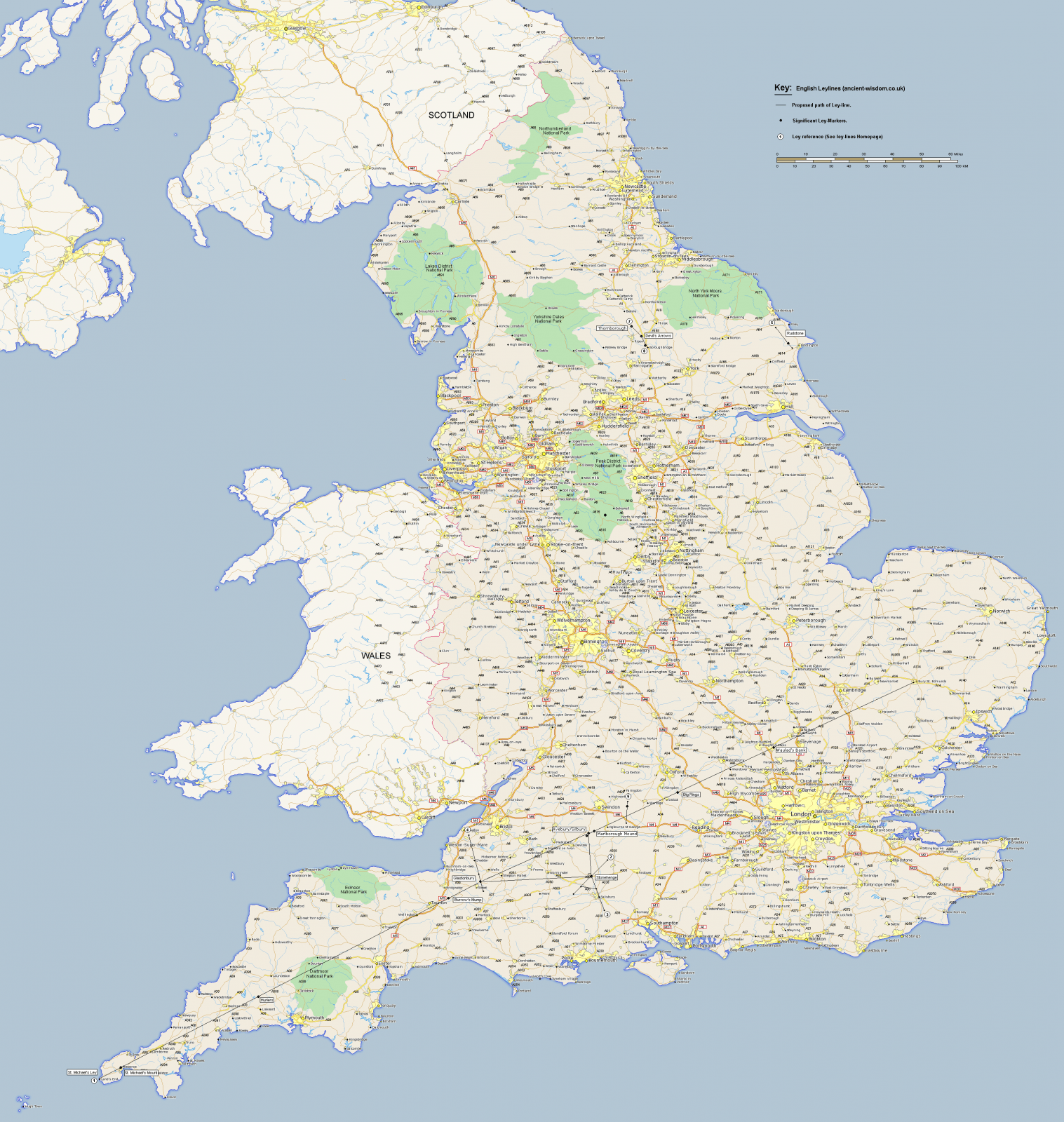
close to a kilometer in width as the scale on this is probably somewhere between 1:1,000,000 and 1:2,000,000, which is common for nation sized maps. The line itself covers a distance of over 500 kilometers. Conveniently, it passes through Avebury as it’s drawn from Bury St. Edmunds in the northeast to Lands End in the southwest. You’ll want to open this image by clicking it or opening in another tab to see the line.
That the line passes so close to Stonehenge it must have made heads explode because a nice, neat set of additional lines link it to the St. Michael’s line with the added bonus of being close enough to perpendicular that the authors felt the could get away with putting a right-angle symbol on the line.
But reflect a bit on the last argument. Is this line really straight? What of the curvature of the earth? I suppose we could argue that ley lines follow the curvature of the Earth. I mean, we’d have to, right? Otherwise we’d have to admit that about half way down this over 500 km line, the ley line is about 20 km below the surface!
But how precise is this ley line? The line on the map provided by “Ancient Wisdom’s” website is pretty thin, right? Let’s see what happens when we go to Lands End in Google Earth, drop a point, then proceed to Bury St. Edmunds and do the same. Then draw a line from one to the other. Zoomed out around the same resolution, it all looks good. It would seem that the line passes right through Glastonbury Tor and Avebury Circle.
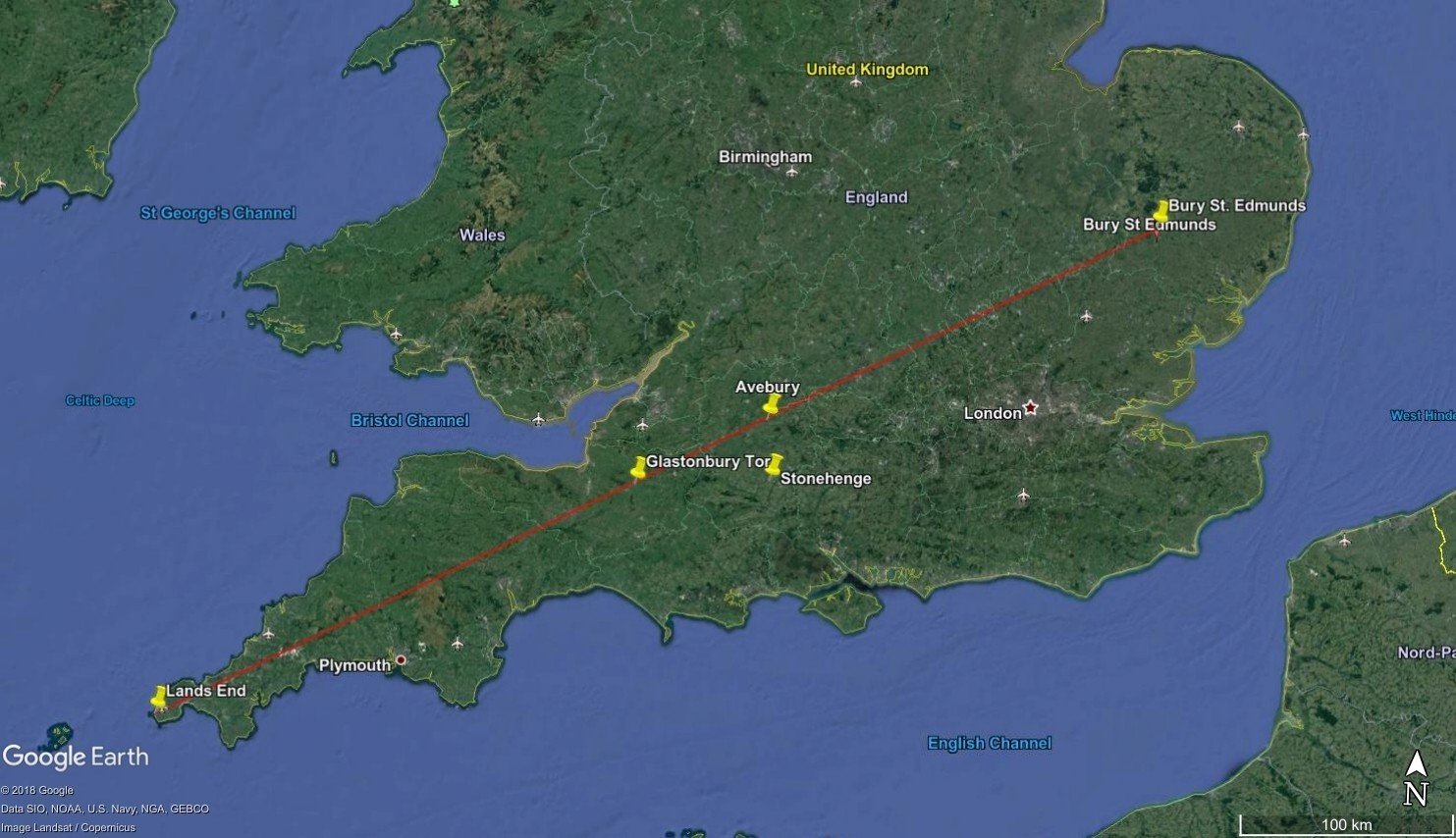
So let’s zoom in and see how it looks.
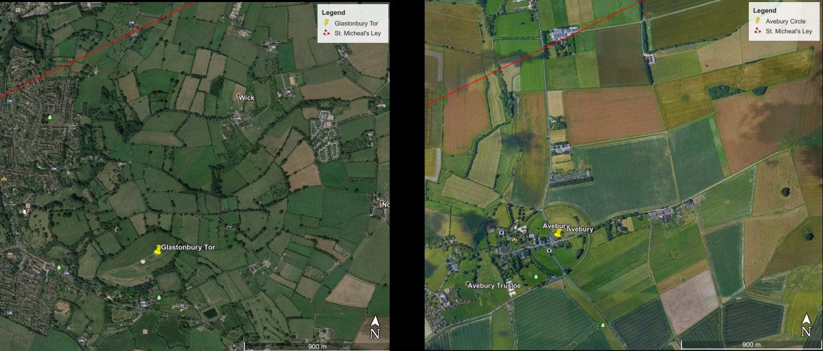
That’s a difference of just a little over 1 kilometer off for each. Both Avebury Circle (the center) and Glastonbury Tor (the peak) are a little over 1 kilometer south of the center of the ley line. This would make the ley line a little over 2 km wide! Can you truly call this precise?
Incidentally, I have to admit if you record the decimal degrees of Stonehenge, Avebury, and Glastonbury Tor, then do a little math, the result is actually two bearings that are 90 degrees apart from Stonehenge to either of the other two. But I have no doubt that I can duplicate this over and over on the British Islands given the sheer number of archaeological sites, churches, and cemeteries. Moreover, is 90 degrees actually important? Why is it more important than 120 degrees? Or 72 degrees? And so on.
#3
The third argument is actually pretty interesting. This is the one that the points intersected by ley lines are only ancient, sacred, special, etc. And not trivial or inconsequential. If this were true, then why can we define ley lines by connecting multiple points of pizza joints across London using a straight edge? Some would doubtless have counter arguments. One being that pizza restaurants are sacred–and I’d be hard pressed to disagree. But if this is the case, then where do we draw the line on special, sacred, or important? Suddenly anything qualifies!
Another counter-argument might be that the study is flawed because city streets in London are linear and naturally pizza places would be along these streets. But I’d answer that this is not a new thing, culturally. We favor linear paths sometimes (maybe not as often as Watkins might have imagined), but the London pizza joint ley lines were not limited to all one street. They spanned many streets, some parallel, others convergent.
#4
The fourth argument is one that science can actually define for the ley line enthusiast! The claim is that there are one or more energies transmitted along ley lines. As it turns out, science has a very good understanding of energy and how to measure it! Many, if not most ley lines proponents claim that this energy is “telluric.” I think this is because it’s a strange word that isn’t encountered very often and so, yeah, “telluric, man!”
Pseudoscience has long made a practice of co-opting the terms of what is already either on the fringes of science or otherwise complicated for the lay person to comprehend. Examples are quantum physics and DNA. “Quantum” is a buzz word among the New Age, ripped from it’s true meaning and applied to all manner of esoteric and mystical bullshit from “alternative medicine” to “positive thinking.” And DNA is misread, misinterpreted, and misapplied to all manner of racist claims ranging from Europeans settling the Americas first to “nephilim” are the reason why people have misshapen skulls in ancient Peru rather than the explanation of artificial cranial modification as is demonstrated by archaeological evidence.
Telluric energy is, quite simply, an “earth current.” It results from a variety of natural causes like the solar wind’s affect on the magnetosphere or geothermal activity below the Earth’s surface. But they can also be generated by man and are used for geophysical prospection where a weak current is applied to the surface of the Earth at one point then measured at another by gauging either the conductivity or the resistivity (which are reciprocal values of each other).
The point is, it’s measurable! Telluric currents are at extremely low frequency (ELF) but quite measurable. But they have wavelengths of 10,000 to 100,000 kilometers. Such an energy doesn’t follow narrow, precise lines along the Earth’s surface, rather they broadcast at a wide range with some waves bouncing off the ionosphere, others penetrating the Earth’s crust or oceans, etc., all traveling outward from the transmitter. In all directions depending on the antenna.
Again, the point is, telluric energy is both detectable and measurable. If telluric energy was being transmitted along ley lines, equipment could fully map each line without knowing where the sacred or important sites of antiquity were.
But maybe it’s a different kind of energy, right? Telluric energy is a form of radiant energy, propagated like any other electromagnetic radiation (radio, microwaves, etc.). Light is another form of radiant energy. But regardless of what form of energy ley line are supposed to use (electric, nuclear, gravitational, ionizing, thermal, sound…), it can be detected and measured.
If proponents want to argue that it’s some form of energy yet to be defined, which cannot be measured or detected, then they might as well come clean and say it’s bullshit. Or magic (which is the same thing). If it’s not detectable, then they can’t know it exists.
#5 & #6
Which leaves the last two premises: ley lines either define the sacred sites or the sacred sites define the ley lines. The classic chicken or the egg. I’ve heard both argued by ley lines proponents. But mostly it seems argued that the sacred sites are placed on the ley lines by “the ancients.” And they’re almost always referred to this way: “the ancients.” Not as prehistoric people, cultures, etc. Not as early inhabitants or early humans. Not as our ancestors (medieval, Bronze Age, Neolithic, Paleolithic, or otherwise). They are nearly always venerated with the term “the ancients.”
This practice really shows the fallacious nature of ley lines in that proponents are appealing to tradition, more specifically, they’re appealing to antiquity. The assumption is that “they knew better than we” and you see it all the time in non-archaeological scenarios. During political debates you will often hear one or more candidates appeal to “the way things used to be” or “the good old days” or “making things great again.” Ignored is any progress made in civil rights, technology, gender rights, medicine, and so on. The same is happening with ley line proponents on a somewhat different time scale.
They see “the ancients” as having had some sort of knowledge or understanding of the universe that is now lost to us. This is how they knew to build their sacred sites on ley lines. Because they, the Neolithic hunter-gatherer who was just beginning to consider maybe he could make seeds become a crop each year or keep some of the wild goats he caught in a pen, also had a means of detecting an energy field transmitted along a “line.” Was it a multi-meter knapped from the finest available chert? A Geiger-counter woven from marsh reeds?
Of course, so many ley lines proponents would no doubt respond with the claim that there was once a civilization completely lost to us now, invisible in the archaeological record, that had “high technology” and were able to do things we could only dream of today. One is always left pondering how it is these proponents know such a civilization existed since, after all, it is completely lost to us. The evidence for such a civilization is often circular. Ley lines are proof that they existed, otherwise they couldn’t have known where to put all their sacred sites. Why can’t we detect these ley lines and their energies today? Because the technology of “the ancients” is lost to us along with their civilization.
Further Reading
Ancient Wisdom (accessed 2018). St. Micheal. http://www.ancient-wisdom.com/stmichael.htm
Galactic Channelings (2014). Project Ley Lines: http://www.galacticchannelings.com/english/Project_Ley_Lines_Update_120114.pdf
Johnson, Matthew (2009). Archaeological Theory: An Introduction (2nd ed.). Wiley-Blackwell. p. 5.
Michell, John (1969). The View Over Atlantis. Sago Press (later Ballentine Books in 1977).
Michell, John (1989). The New View Over Atlantis. London: Thames and Hudson.
Watkins, Alfred (1922). Early British Trackways, Moats, Mounds, Camps and Sites. Hereford, England: The Watkins Meter Company.
Watkins, Alfred Watkins (1925). The old straight track: its mounds, beacons, moats, sites, and mark stones. London: Methuen & Co Ltd.
You’d think that if all these different civilizations/cultures in the past all over the world knew about magic-powered ley lines that at least one of them would have written about them and marked them out clearly labeled as such. But no, that had to wait until 1922 and even then it was obscure for several more decades.
How will we ever power out perpetual motion machines at this rate?