
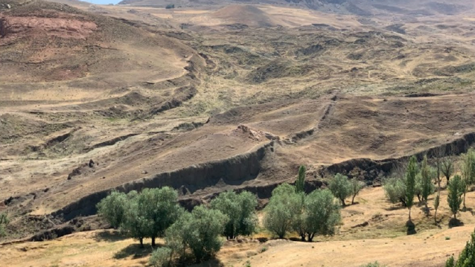
Noah’s Ark has possibly been “discovered” more times than any other artifact or feature mentioned in the Bible. Just when you think news of Ark discovery is in a dormant state, it emerges like a rash to be scratched until it fades away. And, like herpes, no amount of inoculation of fact or reason will make it go away for good.
Here’s a chronological list of times someone claimed to find evidence of Noah’s Ark:
- 3rd Century BCE – 1st Century CE: Early historians like Berossus and Josephus wrote that preserved relics of Noah’s Ark were still visible on a mountain in Armenia/Corduene, and that locals scraped pitch from them to use in protective amulets.
- 4th Century CE: Jacob of Nisibis supposedly scaled Mount Sararad looking for the Ark and claimed to have been visited by an angel who gave him a piece of wood from the Ark itself.
- 1856: Armenian immigrant Haji Yearam claimed on his deathbed that he guided a secret expedition of scientists who located the Ark on Mount Ararat when he was a boy but swore he would not tell about it.
- 1876: After climbing to about 4,000 meters on Mount Ararat (well above the treeline), British scholar James Bryce claimed he recovered a 4-foot, hand-tooled piece of wood. This, he claimed, was possibly a piece of the Ark.
- 1883: The New Zealand Herald published an April Fools’ Day hoax claiming the Turkish government discovered the Ark, which was revealed by an avalanche on Mount Ararat. This story was reprinted globally as authentic in spite of the April 1st date.
- 1887: John Joseph Nouri, a Chaldean archdeacon, claimed to reach the summit of Mount Ararat and saw an intact Ark. Later, he toured the United States as its self-proclaimed discoverer.
- 1902–1908: Armenian-American Georgie Hagopian claimed his uncle took him up Mount Ararat twice as a kid, and he climbed on the roof of a large, moss-covered wooden structure both times. He claimed this was the remains of the Ark
- 1916–1917: Supposedly, Russian aviator “Vladimir Roskovitsky” observed a giant shipwreck on Mount Ararat. This prompted Tsar Nicholas II to send 150 soldiers to check it out before the Bolshevik Revolution suppressed the report. It was later admitted to be a fictional account.
- 1943: U.S. soldier Ed Davis claimed that local Kurdish or Lur villagers took him to a broken wood structure on a mountain during World War II. They said it was Noah’s Ark.
- 1948 / 1959–1960: Turkish Army Captain Ilhan Durup?nar spotted a 500-foot long, boat-shaped feature in NATO aerial photos in 1959 of a region that was exposed by mudflows stemming from earthquakes in 1948. A 1960 expedition determined it to be a natural formation as the team only found “soil and rocks.” The site is named for Durup?nar even today.
- 1952–1955: Yet another “boat-shaped” feature was found by French explorer Fernand Navarra who eventually excavated from it a hand-tooled wooden timber supposedly from under the glacial ice on Mount Ararat. The origin and age of the wood was very questionable.
- 1954: Petroleum engineer George Greene reportedly snapped 6 aerial photographs of still another boat-shaped “wooden prow” protruding from a cliff on Mount Ararat. The original photos were lost after his death in 1962.
- 1977–1980s: Pseudoarchaeologist Ron Wyatt re-discovered the Durup?nar site and claimed he found “petrified wood held together by metal fittings.” The Turkish government declared it a national park in 1986, then geologists confirmed it was geological feature–specifically a double-plunging syncline. A rock-folded layer with evidence of erosion and weathering.
- 1985–1993: Actor George Jammal claimed to have found “ark wood” in an ice cave on Mount Ararat and showed it on a 1993 CBS documentary. He later admitted it was a hoax using ordinary pine wood treated with soy sauce.
- 2003–2004: Hawaiian businessman Daniel McGivern spent half a million dollars researching the Ark and after staring at satellite imagery of the “Ararat Anomaly,” he claimed to identify wooden beams from the Ark and said, “I’m 98 percent sure it’s Noah’s Ark!” His team was denied Turkish research permits.
- 2004–2010: Noah’s Ark Ministries International (NAMI) of Hong Kong claimed to uncover several wooden underground compartments on Mount Ararat that carbon-dated to 4,800 years ago. It turned out that the site was staged using old timber by a local guide.
- 2006: Bob Cornuke, founder of BASE Institute, claimed to find a petrified, boat-shaped wooden structure at 13,000 feet on Mount Takht-e Suleyman in Iran. He said it was the Ark. Geologists eventually identified it as rocks.
- 2020: Archaeologist Joel Klenck issued press releases asserting that photos of timber from Mount Ararat proved Noah’s Ark was a factual archaeological site, a claim rejected by more rational archaeologists as pseudoarchaeology. Also, he was a really strange dude that wandered off from a hiking tour on his own to “find the ark,” taking “pedestrian survey” to a weird level.
I’ve no doubt missed some claims, but these are what I was able to compile from the sources I’ll list at the end of this article. Feel free to make note of a “discovery” of Noah’s Ark I missed in the comments!

Summary of the current “discovery” by Noah’s Ark Scans
Now, in 2026, we have the Noah’s Ark Scans project, led by Andrew Jones who is collaborating with Turkish researchers. They’re promoting a new set of claims at the Durup?nar site that’s based on deep soil cores, ground-penetrating radar (GPR), electrical resistivity tomography (ERT), and the Bakhtar Radar–a proprietary system developed by Khosrow Bakhtar. The promoters argue that they’ve found rectilinear, right-angled features, a central corridor flanked by side-voids, and 3 distinct horizontal subterranean layers that are supposed to be consistent with Biblical descriptions of the Ark.
Why this isn’t Noah’s Ark
There are a couple of main reasons why this site cannot be “100% confirmed Noah’s Ark.” Mainly because there simply was no global flood of this magnitude. It could not have physically happened. There is physically not enough water on or within the Earth to raise sea levels high enough to submerge every mountain peak across all continents at the same time–not enough to bring the water level to the Durupinar site in a way that a large ship could make landfall.
Not only that, but there is a problem with heat. As pointed out by Erika of the Gutsick Gibbon YouTube channel, this is a serious problem for the Flood story and it boils down to thermodynamics. The amount of water required to create a flood on this scale would compress the entire geological column–we’re talking thousands of meters of sediment, continental movement, and radioactive decay–forced into a single flood year. The rate of nuclear decay and tectonic activity would need to accelerate millions of times. It would release about 500 million year’s worth of accelerated nuclear decay and tectonic energy on the scale of 93,000 hydrogen bombs per square kilometer!
Not only would such a thermal release instantly boil the oceans, it would melt the Earth’s crust and vaporize all life aboard the Ark. Of course, a true believer will invoke the magic of a supernatural deity, but that ain’t science since it can’t be falsified.
There are numerous other geological reasons why we know a global flood never occurred, not the least of which includes a well dated geological column that simply doesn’t show it.
From a literary standpoint, Noah is a tradition from a much earlier tale that originated from older Mesopotamian flood traditions like the Epic of Gilgamesh, Atra-Hasis, and the story of Utnapishtim. Archaeological evidence across ancient Mesopotamian cities like Ur, Uruk, Kish, and Shuruppak show evidence of severe, localized river-valley floods along the Tigris and Euphrates, which inspired flood myths that were regional rather than something on a global scale.
False Dichotomy
It seems to me that the claim this is Noah’s Ark vs this is just natural is a false dichotomy. It could be that this is the site of some sort of settlement from antiquity. Or the site of some pastoral activity. Dr. Khosrow Bakhtar himself, the lead scientist doing the radar survey, has even suggested it could be space aliens! He said in The Times, “natural ground does not organise itself into corridors, chambers and hallways. It could be a ship. It could be a spaceship. What I can say from the radar is that it is organised, it is structural.”
Does he really believe it’s a spaceship? Probably not. But it’s every bit as good an hypothesis as a boat that once carried two of every animal on Earth through a global flood. In fact, when you consider all the poop that would produce, space aliens seem a better bet. But my money is still a natural feature. Especially when we look at the methodology of the Noah’s Ark Scans group.
Methodology of the current “discovery”
Passive Scans
Early in their work, the Noah’s Ark Scans team relied on conventional ground penetrating radar (GPR) and Electrical Resistivity/Conductivity Tomography (ERT). I’ve used both of these in archaeological prospection and they each have their pros and cons. I think I prefer ERT in certain soils, particularly after a short rain. You can get it done pretty quickly and cheaply without a lot of specialized software. Just record a numerical value at each defined interval along a series of transects and you can practically just graph the site in Excel.
GPR, however, can give better results since you can get multiple returns at multiple depths. For instance, if your radar transmits over a feature buried at 1.5 meters it can still show stratigraphy below with additional reflections. They show up in real time as little parabolas on the GPR screen. You run it across a series of transects that begin at datum, snaking back and forth with even spacing, turning 180-degrees and onto the next, adjacent transect on the way back. At the end of the job, you save the data, which you can play back on the GPR screen. Or, better still, import into a software package like GPR Slice and render it into something you can look at in 3-D.
I like to describe the fancy 3D product as like a loaf of bread. The top of the bread is the surface you just ran the GPR across and each slice of bread is one of the transects. I always find it better to collect data in “half-loaves” because it’s just a little easier to work with. Stuff in each slice tends to stand out in the data: features (like raisins or dates in a fruit loaf), voids (like in a good sourdough), etc. If a feature shows up in multiple slices, it’s a sure bet there’s something there. Maybe a large rock or a pipe. Perhaps a grave. Tree roots sometimes show up. Buried hearths. Trash pits. Just about anything that can reflect a signal. And, as with ERT, sometimes a light rain can be helpful for shallow features in archaeological zones. Most grave shafts, for instance, show up starting at around 1 m and a light rain can let water collect at the base of a grave shaft since the ground above is less consolidated. This makes the reflection a little more pronounced. Older graves tend to reflect less, since the ground has had more time to re-consolidate in density.
I say all this to note that the final product from the software doesn’t say, “grave shaft here, hearth there. This bit is bedrock and that bit is sand. Voids aren’t labeled as such, and bedrock isn’t always easy to spot, particularly in soils that are dense with clays, cobbles, and debris.
GPR data from surveys done starting in 2014 at Durup?nar were used to claim distinct horizontal layers, linear anomalies, and right-angled geometry were found along with “central void lines.” When anyone was critical, Andrew Jones defended the work by saying GPR is widely accepted and the data are solid. And he showed the world what he called “data” in the form of those pretty 3D heat maps of features. These aren’t data, however. These are interpretations of data. Those 3D representations and their pretty colors are determined by tweaking values and even attenuating the data to get results you want. These are valid, useful steps if you’re trying to verify certain patterns, but they can also result in products that misrepresent the real data underlying it all.
And after 2025, Jones and his team began to rely heavily on “BakhtarRadar,” which has its own set of problems. This is a proprietary version of GPR created by Khosrow Bakhtar who claims it can scan at greater depths with greater accuracy. I’m not sure what the Noah’s Ark Scans team likes more about him: his radar system or his background. They’ve repeated touted him in press releases as being their “U.S. Defense scientist” whose revolutionary new geophysical survey system will challenge decades of scientific dogma. And so on.
The problem with his proprietary system is it doesn’t work very well. Peer-reviewed evaluations of his work, which previously went by the name “EarthRadar,” showed that it produces 3D images derived largely from internal equipment self-clutter noise instead of actual sub-surface targets. Geophysicists who looked at his system and evaluated it actually said his claims of effectiveness violate basic electromagnetic propagation laws. In other words, it’s bullshit.
Drilling Soil Cores
The Noah’s Ark Scans team appears to be using a Geoprobe Systems machine (probably a 3126GT) which is a combination rig. Meaning it can auger soil as well as use a sonic or rotary core head to drill rock formations. Most of the photos I saw showed it only configured for soil, but I’m not surprised they shattered a bit on a hard object at around 4-5 meters in one of their holes. It’s a mudlow on a stratovolcano so there are going to be cobbles and boulders of everything from limestone to basalt in it. The CFA (continuous flight auger) bit in their photograph rotates at a relatively low speed, but with a lot of torque, making it really good for scooping loose dirt, silt, and clay. Once you hit bedrock, if the downward pressure by the operator isn’t stopped, the auger can be snapped, sheared, or at least twisted and warped.
The other photo they showed is evidence of a torque spike that sheared the coupling. My guess is there’s a broken bit and a lower section of pipe still in the hole. The Geoprobe was clearly in sonic percussion mode, probably hammering away at around 7,000+ times per minute, rotating between 80-120 RPM. Downward force is something on the order of 20,000-50,000 pounds.
They said they hit something “harder than limestone” but don’t really say how they know this to be true. Limestone would totally do this because of the density of the rock surrounded by packed soil to create the barrier. Particularly if they suddenly transitioned from a soft layer to an unexpectedly hard object. On a stratovolcano field, culprits could be anything from limestone or graywake to a chert nodule or basalt boulder buried in mountain mudflow.
Of course, the folks on the ground with a conclusion they arrived with (that this is “100% Noah’s Ark”) only suggest data that fit that conclusion: petrified wood.
Noah’s Ark Scams?
Critics have pointed out that Andrew Jones, the founder of this team and their project coordinator, has no formal training or background in archaeology. To be fair, this is something Jones, himself, acknowledges. But he’s also described as a publicity seeker who uses tabloid media and press releases to communicate what is alleged to be scientific information.
Jones has also made some obviously premature claims declaring the site “100 percent confirmed” to be man-made. At least one headline I saw said, “100% confirmed to be Noah’s Ark.” Yet no data are published or available for confirmation.
Khosrow Bakhtar, the creator of BakhtarRadar, is promoted in the media as a “U.S. Defense scientist,” but his military contracts involved sensors for IEDs and ammunition storage facilities rather than archaeological prospection technology. His radar system is deeply flawed, ineffective, and not something anyone serious about collecting data should want associated with their research. It failed rigorous, double-blind testing by the U.S. Army, giving results that were no better than guessing since the 3D images produced were generated from internal equipment self clutter-noise.
The biggest red flag on this team is Lauren Witzke, the project’s marketing and fundraising person. She’s a highly-divisive and far-right political activist who has promoted several conspiracy theories and displayed significant racism. Not only is she a creationist, she’s a flat-earther–one who literally flew half-way around the globe to be on-site at Durup?nar and make videos.
Worst of all are the blatantly racist and hateful attitude she has for absolutely anyone who isn’t her kind of white. She displayed a photo of a page from Hitler’s Mein Kampf, giving it praise. She’s stated a better “final solution” is needed that doesn’t kill whites. She refers to “the browns” who need to be deported and calls them “turd world savages.” And so much more.



Conclusions
When it comes to Noah’s Ark, there is a recurring nature to the claims that show why it’s fair to call it the “herpes of pseudoarchaeology.” It’s a dormant myth that re-emerges with periodic media flare-ups (that are annoying if not occasionally painful to endure) whenever some amateur researcher or publicity seeking group puts out a press release. And these announcements almost always bypass peer-reviewed scientific channels to rely instead on sensationalized newspaper and social media announcements, press releases, unvalidated GPR scans, and an abundance of anecdotal claims all designed to capture public attention. At the end of the day, however, rigorous scientific scrutiny always shows the claims for what they are: a pretense at scientific discovery that began with a conclusion to which data that fit are kept and those that don’t are rejected. The Durup?nar site stands as a textbook example of geological misunderstanding combined with unabashed apophenia.
Decades of geological investigations, much of it peer-reviewed, have thoroughly debunked the notion that the Durup?nar formation is anything but natural. It is not man-made. Field studies by geologists like Lorence Collins and David Fasold established that its boat-shaped outline is the result of an eroded, doubly plunging syncline. It was formed when previously horizontal sedimentary rock layers were uplifted and compressed into a U-shaped trough.
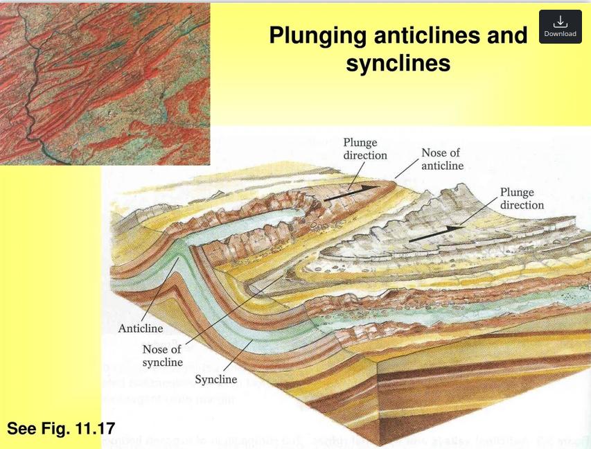
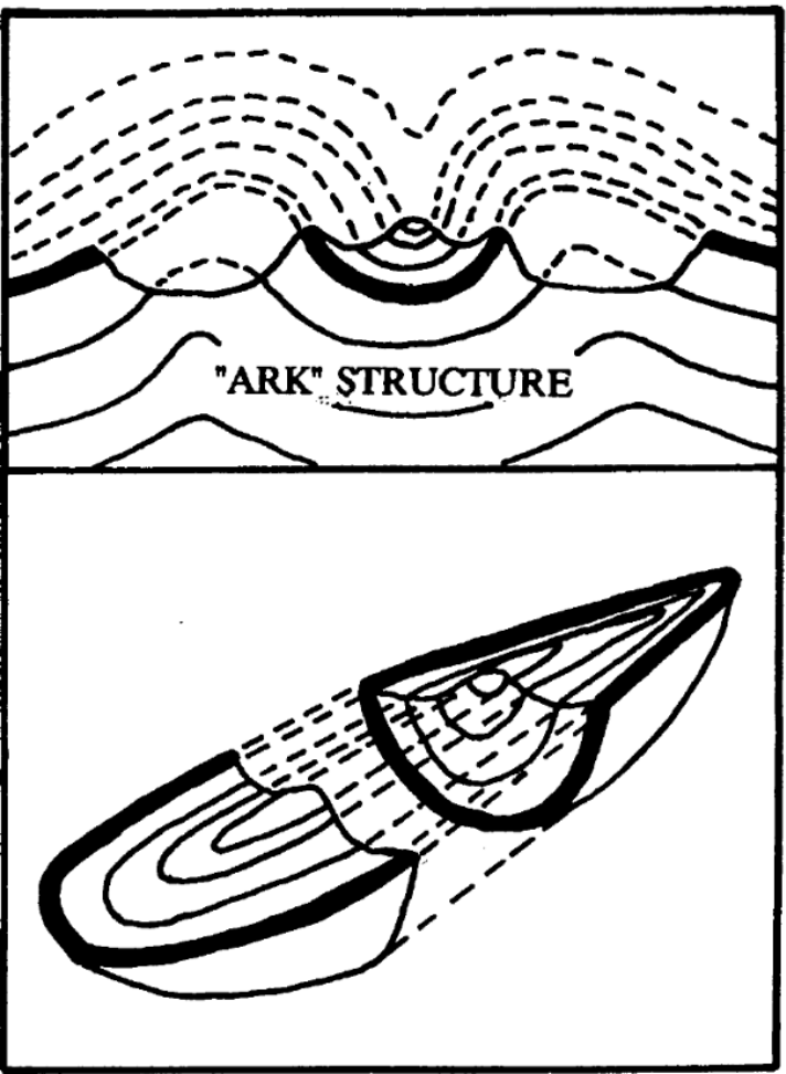
Microscopic and chemical analyses have already identified natural concretions of limonite and magnetite along the fracture planes. In the 1980s and 1990s, and then later in 2025, geologists confirmed the ship-like symmetry of the formation was the result of volcanic debris, lahars, and landslide mudflows (part of the Great Telçeker Earthflow) that encountered this obstacle, flowing around its synclinal ridge and eroding the edges into the “hull” shape.
Andrew Jones has variously hand-waved these explanations with things like “we found no bedrock in our drills or scans” and “the flow tapers at the wrong side” etc. But he never shows the data. I’m talking about raw borehole tables that include borehole ID, core runs, start depth, end depth, recovery percentages, material descriptions, sample IDs, etc. There’s no accounting of all the variables that lahar and mudflow dynamics that can affect interactions with geological features like eroded synclines. Variables like water to sediment ratio, how clays can affect the flow (it can act as a cohesive binder, retain water, etc.), grain size and distribution, trigger variables, slope, channel confinement, channel resistance, did the flow grow or taper as it traveled downslope, and so on.
When you consider all this along with the insurmountable physical obstacles of a global flood (lack of sufficient water on the planet, a catastrophic thermodynamic heat problem, etc.), it’s pretty obvious that claims that this is “100 Percent Noah’s Ark” or even “100 Percent Man-Made” rely on tossing out basic physics and geology. The Durup?nar formation is, and remains, a completely natural formation of geology. One that can provide some valuable insight into the mechanics of lahar and mudflow events. But it’s also a site that has attained mythical status. The Turkish government promotes it as a tourist location and there’s even a visitor’s center and small museum established adjacent to it.
I don’t agree with what the Noah’s Ark Scans team is doing. There seems to be a level of grift going on and it’s been tied to a precious metals investment scheme that suckers unsuspecting “investors” who ultimately become the victims of relentless high-pressure sales calls. Then there’s the completely racist viewpoints of their fundraiser, Lauren Witzke, that makes me wonder if the entire venture isn’t some front for a Great Replacement conspiracy group. And they are asking for donations. That said, the Durup?nar site and Mount Ararat itself can function as a sacred landscape or cultural anchor, providing religious validation to those that find value in the stories from ancient texts. In a world where division and exclusion seem so casually normal, it would be nice to have a place that brings people together.
References and Further Reading
Atabey, E. (2025). Noah’s Ark: A Geological Structure Formed By a Landslide. Retrieved on October 10, 2026 from, https://www.researchgate.net/publication/392866505_NUH’UN_GEMISI_HEYELAN_ETKISIYLE_OLUSMUS_JEOLOJIK_BIR_YAPI#read.
Bai, X., Yang, Y., Wei, S., Chen, G., Li, H., Li, Y., Tian, H., Zhang, T., & Cui, H. (2023). A comprehensive review of conventional and deep learning approaches for ground-penetrating radar detection of raw data. Applied Sciences, 13(13), Article 7992. https://doi.org/10.3390/app13137992
Canpolat, E., Yulu, A., Keserci, F., Demir, E., & Bayrakdar, C. (2026). The geoheritage of Mount Ararat and its vicinity: An assessment of geodiversity with a focus on glaciation and mountaineering. Geoheritage, 18, Article 38. https://doi.org/10.1007/s12371-026-01050-x
Collins, L. G. (2011). A supposed cast of Noah’s ark in eastern Turkey. Department of Geological Sciences, California State University, Northridge.
Collins, L. G., & Fasold, D. F. (1996). Bogus “Noah’s Ark” from Turkey exposed as a common geologic structure. Journal of Geoscience Education, 44(4), 439–444. https://doi.org/10.5408/1089-9995-44.4.439
Conyers, L. B. (2012). Interpreting ground-penetrating radar for archaeology. Routledge.
Daniels, D. J., & Utsi, E. (2013). GPR case histories and known physical principles. The European GPR Association.
Judkins, A. (2025). Durup?nar debunked: A comprehensive analysis. Retrieved October 1, 2026, from https://aaronjudkins.substack.com/p/durupinar-debunked.
Feagans, C. (2010, May 13). Noah’s Ark found… again. Archaeology Review. https://ahotcupofjoe.net/2010/05/noahs-ark-found-again/
Feagans, C. (2020, December). The pseudoarchaeology of Noah’s Ark. Archaeology Review. https://ahotcupofjoe.net/2020/12/the-pseudoarchaeology-of-noahs-ark/
Geissler, R. (2008). Mount Ararat archaeological survey. Bible and Spade, 21(3), 70–96.
Guner, Y. (1986) Is Noah’s ark on Mt. Ararat? Geomorphological development on the Dogubayazit-Telceker landslide which is assumed to be related to Noah’s Ark: Jeomorfoloji Dergisi, v. 14, p. 27-37.
Gutsick Gibbon (n.d.). The heat problem got worse [Video]. YouTube. Retrieved on October 1, 2026 from https://www.youtube.com/watch?v=IdRyZhwWQjg.
Habermehl, A. (2008). A review of the search for Noah’s Ark. In A. A. Snelling (Ed.), Proceedings of the Sixth International Conference on Creationism (pp. 485–502). Creation Science Fellowship & Institute for Creation Research.
Kaloustian, G. C. (2026, June 8). Has Andrew Jones found Noah’s Ark? A patient researcher builds his case. Blaze Media. https://www.theblaze.com/lifestyle/has-andrew-jones-found-noah-s-ark-a-patient-researcher-builds-his-case
Klenck, J. (2020, December 7). Archaeologist: Noah’s Ark a fact and matches three non-biblical accounts. Retrieved December 15, 2020, from http://www.releasewire.com/press-releases/archaeologist-noahs-ark-a-fact-and-matches-three-non-biblical-accounts-1319038.htm.
LaHaye, T. & Morris, J. (1976). The Ark on Ararat, Nashville: Thomas Nelson Inc. and Creation Life Publishers, pp. 69-72.
Shea, W. H. (1976). The ark-shaped formation in the Tendurek Mountains of eastern Turkey. Creation Research Society Quarterly, 13(2), 90–95.
Wikipedia. (n.d.-a). Durup?nar site. Wikipedia. Retrieved October 15, 2026, from https://en.wikipedia.org/wiki/Durup%C4%B1nar_site
Wikipedia. (n.d.-b). Searches for Noah’s Ark. Wikipedia. Retrieved October 15, 2026, from https://en.wikipedia.org/wiki/Searches_for_Noah%27s_Ark
Witten, A. J. (2006). Handbook of geophysics and archaeology. Routledge.

Leave a Reply