
Former U.S. Army officer and mathematician published a paper about a worldwide flood in the journal Mediterranean Archaeology and Archaeometry. And it’s nearly completely based on pseudoscience.
I first noticed this paper after seeing an article on pseudoarchaeology website, Ancient Origins, by Dr. Michael Jaye. You know he’s a “Dr.” because he has “PhD” after his name on the cover of his 66-page pamphlet (affiliate link) you can buy on Amazon for a mere $39. Or you can just go to his website, where he laid everything out for free. Or you can go to his “peer-reviewed” article in Mediterranean Archaeology and Archaeometry (2019). This is a journal that is quickly gaining traction with the purveyors of pseudoscience since it would seem their editorial and peer review process is extremely lax if not completely pay-to-publish.
Origins article now missing.
The title of the Ancient Origins article was “Debunking the ‘No Flood, Ever’ Theory: Scientific Bathymetric Evidence.” What I find interesting is that the article no longer exists on the AO website. But the lead for the article once read, “For almost 200 years geologists have accepted that the Earth has had all its water since nearly the beginning. This paradigm finds its origin in the early decades of the 1800s when European…” Luckily I have a screen capture to share.
Michael Jaye’s bio is also gone from their site. Below is a screen capture of it. His former member/user ID was 99137 and it outlined his education in applied mathematics, military service with a MLRS unit, and retirement in 2009, etc. As of 26 September 2019, Jaye was a member of AO for about 4 weeks. Apparently, he isn’t any longer.

I have no idea why and I suppose it doesn’t really matter. I just find the interactions between pseudoscience proponents and their peers to be a subject of interest. Perhaps that’s the anthropologist in me. Either he decided, for whatever reason, Ancient Origins wasn’t the venue for him; or AO decided they didn’t want to host his special brand of woo, in which case I’d be shocked.. SHOCKED… to find editorial standards at AO that exceed those of Mediterranean Archaeology and Archaeometry. Maybe there were comments at the end of his article that got out of hand for him. I read the article and made a few notes, but I didn’t read the comments.
So what’s this ‘worldwide flood’ stuff?
Special note: As usual, Rebecca Bradley has already beat me to the punch and written an article on Jaye at The Lateral Truth, which I discovered as I started writing my own. I intentionally avoided reading it until I finish this review, then I’ll go back and see what I missed. Hopefully, we’ll have slightly different perspectives, but I’m sure Rebecca’s will be the more complete.
Jaye’s Ancient Origins article pointed to the journal article in MAA mentioned above, so I’ll use MAA as the the primary jumping off point for this review of his claim. In the AO article, Jaye stated, “today’s lettered geologists staffing the science’s premier journals do not know the source of their fundamental ‘no flood, ever’ tenet. They simply accept it as an article of their faith, and they immediately discount anyone thinking otherwise.”
- The “no flood ever” premise is one of his core premises. In the MAA article, he brings more detail and additional premises better defined
- There was a cosmic Impact ~12,800 years ago in the “Southern Ocean.”
- The impact caused a worldwide flood
- The water from this flood inundated the Mediterranean Sea from the Strait of Gibraltar
- The flood and impact account for Younger Dryas effects.
- Cultural mythologies of floods corroborate “the scientific record” which he considers evidence of a global flood.
- Geology, as a discipline, holds a “no flood, ever paradigm.”
- Humans originated not from Africa but, rather, a location 3 km below current sea level
I’ll review some of these premises in no particular order.
Human origins not of Africa?
Honestly, there are likely many now-inundated sites of early human and hominid habitation that we may never discover. In fact, this is a hypothesis shared by many archaeologists looking at coastal regions around the world from California to the Arabian Peninsula. But what Jaye is saying is that there are data that show humans once inhabited the regions we now consider to be oceans. This water, you see, wasn’t there (we’ll dive into this more in a moment).
Among the several lines of evidence Jaye suggests are DNA, the Madeira Abyssal Plain, undersea channels, and crater fields in Argentina.
DNA
In the past few years, advances in ancient DNA (aDNA) methods led researchers to discover what they call “population Y”—the ‘Y’ stands for ypykuéra. In Tupi, the language of the Suruí and Karitiana people, this means ancestor. These are the people in Brazil who have this aDNA signal which more closely matches them to people in Australasia than perhaps other Native Americans. In Jaye’s mind, this means these two people, now separated by the Pacific Ocean, shared a common ancestor. This, however, is where Jaye’s mind and those of people who specialize in the various relevant fields of study begin to part ways.
Most researchers in aDNA (the ones with PhDs in genetics, not the ones with PhDs in math and Google Earth Anomaly Hunting), are willing to say they don’t know exactly where this population of last common ancestors was. They do, however, find it logical that it be somewhere in Asia since both the resulting populations migrated to their current homes. We also know that people definitely migrated across the Beringia land bridge. So, it stands to reason, that if this Population “Y” in Brazil migrated from that direction, they did so as a small, relatively fast-moving group since their DNA has yet to be found in North America. But these same researchers also point out that we have still only scratched the surface of aDNA data in North America.
It’s important to note that just because specialists in a given field think one way (based on perhaps hundreds of lines of evidence in geology, biology, anthropology, linguistics, tectonics, genetics, archaeology, etc.) doesn’t mean that a non-specialist who’s degree is in mathematics can’t be right and they wrong. It does, however, mean that Jaye has some big hurdles and those potentially hundreds of lines of evidence to address. Let’s look at two ways he tries this:
Lemuria and Atlantis.
I’m not kidding. These are two of his central ideas.
Lemuria is a fictional land promoted by early theosophists and antiquarians like W. Scott-Elliot, Edgar Cayce, and James Churchward at the turn of the 19th and 20th centuries. And Jaye’s assumption that this mythical land is real is borderline humorous, but hints at the racial underpinnings of this now discredited hypothesis. I should say, it isn’t clear that Jaye intends a racist explanation. But he does inject some statements of, “this is why there are black people,” and “this is why there are white people” (paraphrasing) and “this is why humans do not originate from Africa,” etc. which do have racial implications that accompany them.
Originally, Lemuria was a hypothetical land bridge used to explain some questions that once existed about speciation. Specifically, the discovery of the fossils of lemurs on both Madagascar and the Indian subcontinent which suggested a connection that 19th century zoologist, Philip Sclater had a hard time wrapping his head around. Sclater’s classification of “lemur” was a bit more inclusive than it is today. But the idea that both Madagascar and India were once part of the same, larger continent helped put these remains in a context he could understand.
All in all, this was pretty descent hypothesis for 1864. And he put a name to this continent: “Lemuria.” Even though people like Franklin Coxworthy, Roberto Montovani, and Wm. Henry Pickering were contemplating early notions of continental drift around the turn of the 19th to 20th century. Eduard Suess even proposed the idea of Gondwana in 1885, plate tectonics and continental drift were still not seriously considered or even accepted until Alfred Wegener’s hypothesis. He presented this to the German Geological Society in 1912 but it still wasn’t confirmed beyond any shadow of a doubt until the 1950s by the results of Marie Tharp and others who used cartography and data from seismography and magnetic geophysics. This story is a lot more involved than I make it out to be here, so I’ll toss a few suggested readings at the end.
The short version is until plate tectonics was sufficiently understood, land bridges and “lost continents” were frequently used to explain questions like, “how did lemurs show up in the fossil records of two different continents?”
And, like so many cutting edge scientific hypotheses even today, there were those that wanted to use Lemuria as a means to explain their own conclusions about the way the world is.
One of these was Ernst Haeckel (1834-1919) who quickly surmised that Lemuria was the origin of all human civilization:
Sclater has given this continent the name of Lemuria, from the Semi-apes which were characteristic of it. By assuming this Lemuria to have been man’s primaeval home, we greatly facilitate the explanation of the geographical distribution of the human species by migration.
Haeckel included a map of his idea of human dispersal in his Natural History of Creation, quoted above. He called it a “hypothetical sketch of the monophyletic origin of the extension of the 12 races of man from Lemuria over the Earth.” It’s easy to look at the works of Haeckel and his contemporaries, as they tried to sort out the complexities of human evolution and diversity along with the apparent migration and dispersal of humans as a species, and see what we, today, would quickly reject as racially charged language. You can see it in Haeckel’s “hypothetical sketch.” But we really have to contextualize this with the limits of science in the 19th century.
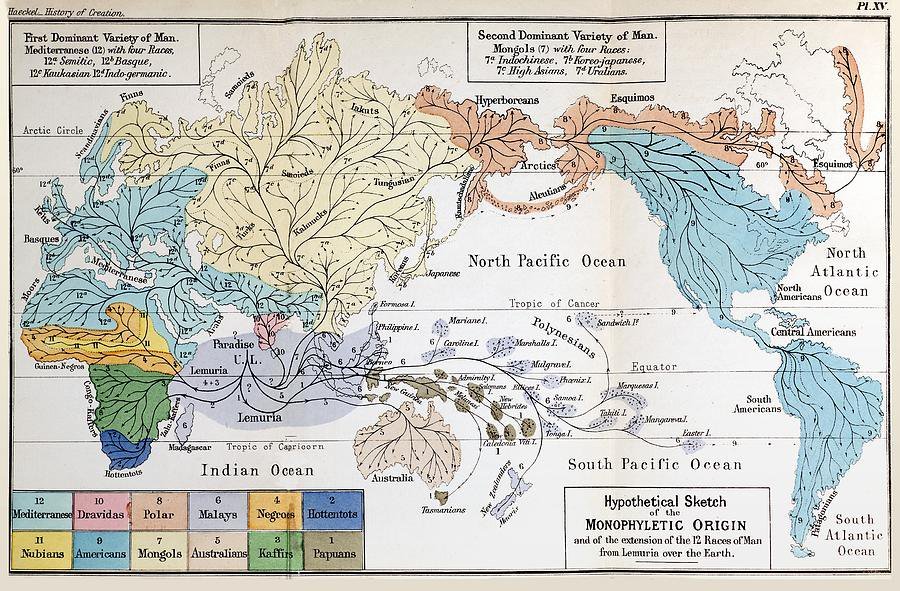
from Lemuria over the Earth. From Haeckel (1887)
While Haeckel was arguably doing genuine science (to the best of his 19th century ability), there were those that were somewhat less logical and rational in their efforts.
In 1904, theosophist William Scott-Elliot, wrote the paper, “the Lost Lemuria,” in which he attempted to expand upon the idea that there are “root races.” This was a racist notion invented by Helena Blavatsky, who started the theosophist movement in the United States. Not satisfied with Sclater’s Lemuria being situated in the Indian Ocean, Scott-Elliot moved it to the Pacific Ocean where it would be more convenient to the conclusions he had about race. According to him, the average Lemurian was a giant “somewhere between twelve and fifteen feet” tall. Its skin was “very dark, being of a yellowish brown color” and:
“He had a long lower jaw, a strangely flattened face, eyes small but piercing and set curiously far apart, so that he could see sideways as well as in front, while the eye at the back of the head – on which part of the head no hair, of course, grew – enabled him to see in that direction also. He had no forehead, but there seemed to be a roll of flesh where it should have been. The head sloped backwards and upwards in a rather curious way. The arms and legs (especially the former) were longer in proportion than ours, and could not be perfectly straightened either at elbows or knees; the hands and feet were enormous, and the heels projected backwards in an ungainly way. The figure was draped in a loose robe of skin, something like rhinoceros hide, but more scaly, probably the skin of some animal of which we now know only through its fossil remains. Round his head, on which the hair was quite short, was twisted another piece of skin to which were attached tassels of bright red, blue and other colors. In his left hand he held a sharpened staff, which was doubtless used for defence or attack. It was about the height of his own body, viz., twelve to fifteen feet. In his right hand was twisted the end of a long rope made of some sort of creeping plant, by which he led a huge and hideous reptile, somewhat resembling the Plesiosaurus. The Lemurians actually domesticated these creatures, and trained them to employ their strength in hunting other animals. The appearance of the man gave an unpleasant sensation, but he was not entirely uncivilized, being an average common-place specimen of his day.”
And this passage is but a smattering of the fascinating, yet nonsensical descriptions of Lemurians and the consequences Lemuria had on the sub-races descended from them. I’m sure I need not mention Scott-Elliot, in keeping with theosophical tradition, provides not a single shred of physical evidence.
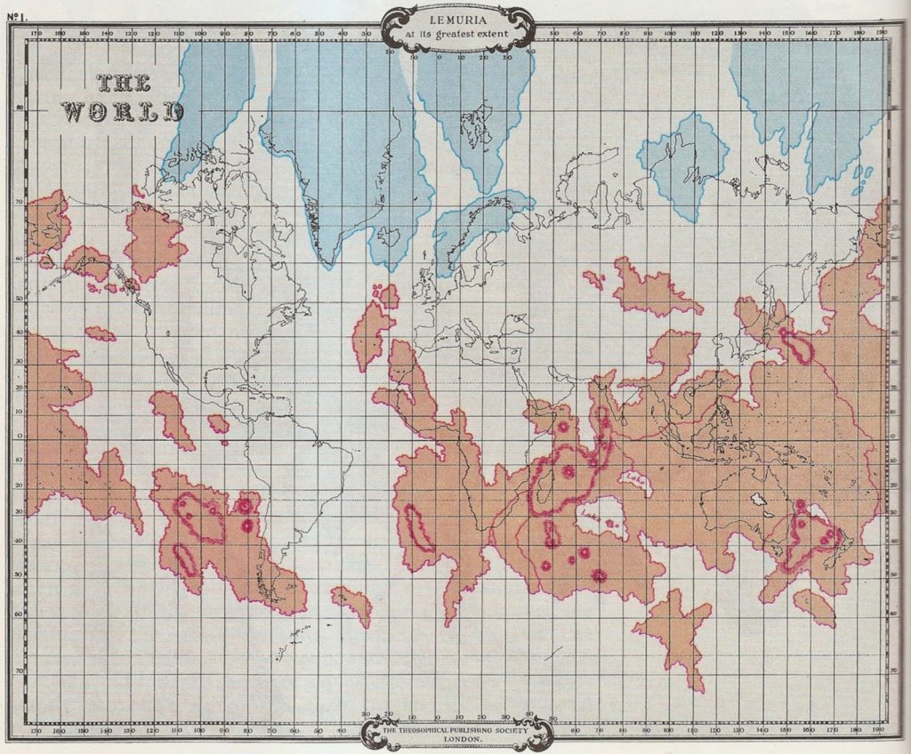
Theosophical Society of London (1896).
Now, back to Michael Jaye.
Central to one of his core premises is that Lemuria and Atlantis are the origins of man. Already, you can see the theosophical similarities and I’ve only barely touched on the deep, racial and pseudoscientific history of Lemuria. We didn’t even mention the works of James Churchward, who also puts the lost continent of Mu in the Pacific Ocean, and writes of artifacts and features he encounters on his travels in The Lost Continent of Mu Motherland of Men (1926). Or the supernatural ramblings of Edgar Cayce who recounts an “international conference” held in Atlantis in 50,722 BCE. Cayce also had some seriously racist claims, not the least of which was one of polygenism, in which he described Earth has having five races of people (white, black, brown, yellow, and red) and that they were all created separately but at the same time and in different places on the planet.
In looking at Jaye’s MAA paper, his claims really seem to be a modern re-telling of some old ideas. While the early 19th and 20th century theosophical propositions were racist, we can, in some ways, look at them as products of their time and view them in that context. But I’m really not sure what to make of Jaye’s comments either in his paper or on his webpage.
Humans evolved in equatorial to near-tropical latitudes in the dark tan regions; we are not out of Africa. Variations in human skin pigmentation are explained by the map: deeper, less equatorial regions produced lighter-skinned humans because the atmosphere’s thickness would have attenuated higher wavelengths (e.g. UV, blue); higher altitude and/or more equatorial habitats led to greater melanin content in human inhabitants.
Excerpt from Jaye’s MAA paper (2019: 80).
We find evidence of pre-flood human activity nearly exclusively in tropical latitudes because, at more than 3 kilometers (two miles) above the former sea level, most of the yellow regions on Fig. 2 were too cold for human habitation. An immediate consequence: Fig. 2 should transform anthropology because furless humans evolved in tropical and near-tropical portions of the tan regions; we are not out of Africa.
Excerpt from Jaye’s webpage at http://theworldwideflood.com
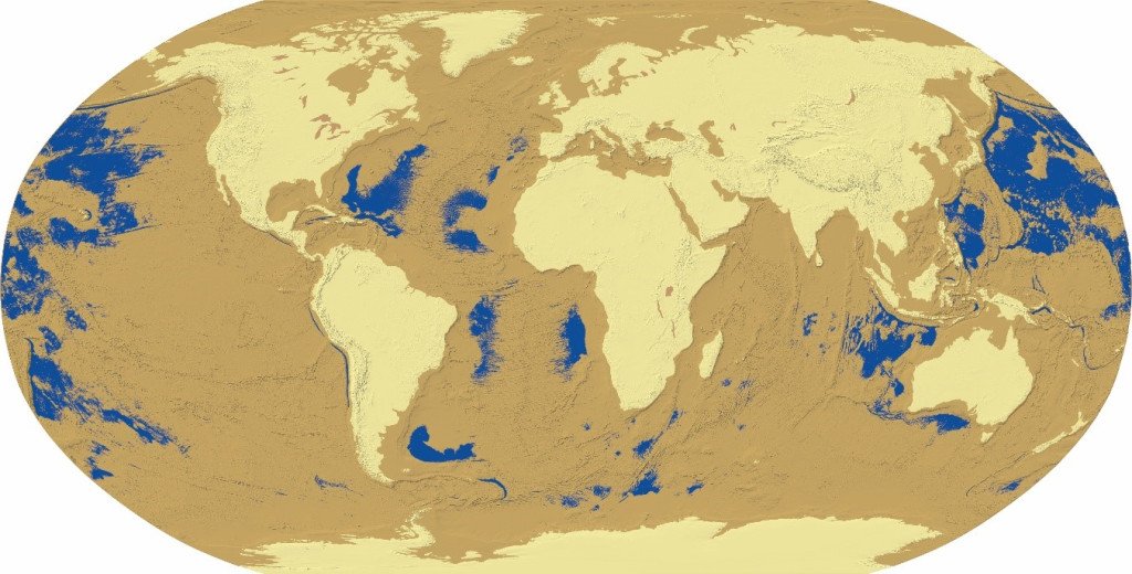
The map above is what Jaye claims is a representation of what the Earth looked like prior to a comet impacting the planet 12,800 years ago. He rendered the map through ArcGIS by removing 3 kilometers of water. The blue areas, he says, are the only water the Earth had. The light-tan areas are modern continents where people didn’t live because it was too cold. The dark-tan regions are where people came from. And its in these areas between the Americas and Asia that he believes Lemuria once existed. With Atlantis being just off the west coast of Africa.
While it’s true that UV radiation increases considerably with each kilometer of increased altitude due to less filtering by the atmosphere, it’s probably not true that people of higher altitudes that aren’t within 20 degrees of the equator are more likely to have darker skin than those of equatorial regions. This is because UV radiation from the sun is more direct than at higher latitudes. In other words, the angle of the sun has more to do with melanin production than altitude. Regardless, we know that the “yellow regions” of his map were certainly not “too cold” for humans since we have a significant body of physical evidence that goes back thousands of years before his imagined comet.
Physical Evidence
Naturally, Jaye fully explains away the mountain of physical evidence for hominid evolution and provides new evidence for Lemuria and Atlantis, right?
Yeah… not so much.
On his webpage, Jaye claims the “yellow regions” on the map above were too cold for human habitation. We know this not to be true based on artifacts and human remains found that date to well before his comet. But he also claims that there are many undersea features that prove his claims.
Among these are what he calls “river channels.” “How,” he might like us to ask, “can rivers create channels if the land wasn’t already exposed?” One such example he points to is the Baker Sea Channel. And this isn’t the only one he points at. Between his paper and his webpage there are several “river channels” at depths he suggests are not possible unless there was once dry land.
I’m all for people showing an interest outside their disciplines and even making discoveries. But if do this, you either have to trust the conclusions of specialists in the discipline you’re stepping into, or be ready to do ALL the coursework (or an equivalent) in that discipline. In my opinion, Jaye has not done either.
Instead, Jaye seems to spend hours pouring over Google Earth, probably zooming in and zooming out, panning left and panning right… until he sees something that catches his eye. Then his mind, not educated enough to understand what he sees, tries to fit it into a conclusion he already has: that there was a worldwide flood.
The Geology of Undersea Sedimentation

Gazetteer Placedetails) http://marineregions.org/mrgid/6538
The Baker Sea Channel is the result of gravity flows and turbidity currents associated with alluvial sedimentation. In fact, this is the nature of millions of channels like this all over the world. Not only are they fairly well understood, they’ve been modeled extensively and the formation processes have been observed in real time (Mulder 2011). Like all sub-disciplines of scientific study, there are definitely some things that aren’t known about these processes, but enough is known to say confidently that they weren’t once rivers before a world wide flood occurred submerging them. In fact, one of the ways we know this is the mere fact that many of them have been observed to be formed either due to seismic activity, alluvial deposition, and general slumping due to gravity. Sedimentation in these channels is very different from that of terrestrial channels.
result of faulting and seismic activity. Photo: (Marine Gazetteer
Placedetails) http://marineregions.org/mrgid/4616
One of these, the Madeira Abyssal Plain (MAP), is what Jaye believes was Atlantis. The crisscrossing, rectilinear features on the ocean floor appears to especially capture his imagination. In fact, this undersea feature covering several hundred square kilometers southwest of Madeira Island near the west coast of Africa frequently shows up as a favorite go-to “anomaly” by “anomaly hunters” sitting behind a Google Earth screen. Jaye calls the crisscrossing fracture lines “canals” and informs readers of his MAA paper that for “the purpose of comparisons, we need to convert these measured distances to stadia.” Though he doesn’t really say why this needs to be done.
We’re meant to assume it has to do with Plato’s Atlantis allegory from Critias, which he includes a passage from, since Plato’s story described the canal or “ditch” that surrounded Atlantis to be 10,000 stadia in length. Which is why Jaye describes that combined length of the fractures as “roughly 1,775 km.” So Jaye defines a stadium as about 185 meters according to the Oxford English Dictionary (OED) and does a little conversion math and proclaims all the fractures (which he calls canals) add up to “9600 stadia, which is within 4% of Plato’s reported 10,000 stadia.”
If you read my article on the pseudoarchaeology of Glenn Beck, you might have noticed a section where I talk about the stadium as a unit of measure. It comes from the Latin word stadium, which is from the Ancient Greek word ![]() (stádion). For the Greeks, one stadion was 600 podes (“podes” is the plural of “pous” which means “foot.” Think of the word podiatrist–a foot doctor).
(stádion). For the Greeks, one stadion was 600 podes (“podes” is the plural of “pous” which means “foot.” Think of the word podiatrist–a foot doctor).
The length of the pous, or foot, in the Greek world had regional variation, so, as you can imagine, historians and the like have been arguing about what the actual length of a stadion might be for years. It also might not surprise you that, depending on which measurement is assumed for the stadion, different results can be interpreted from ancient texts that use it.
But many scholars agree that 157.7 meters (517.3 feet) is a reasonable figure to assume. It was arrived at by Lev Vasilevich Firsov (Engels 1985:306), who applied modern measurements to 81 original measurements provided by Eratosthenes and Strabo:
[H]is methodology is a simple one. He takes 81 measurements of distances recorded by Eratosthenes and preserved mainly in Strabo. For each one, he divides the straight-line distance by the number of stades recorded by Eratosthenes. Finally, he averages the 81 lengths of the stades he derives from this method and obtains 157.7 meters for the length of Eratosthenes’ stade.
Donald Engels (1985). The Length of Eratosthenes’ Stade. American Journal of Philology 106 (3), page 306
So if we use the better candidate for a stadium, the overall length of the MAP fractures, if stacked end on end, is 11,253.5 stades if we accept Jaye’s initial estimate in meters. The margin for error now becomes 12.5%. But this is really all meaningless. Partly because correlation doesn’t imply causation. But mostly because the Madeira Abyssal Plain isn’t Atlantis! Even if we were to accept that Plato’s story was based on fact (and there simply is no good reason to think this is so), the MAP is a fairly well understood undersea formation. And it’s been well studied!
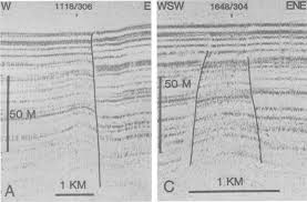
Initially, the site was subjected to intensive study and research back in the 1970s when it was being considered as a site for disposal of radioactive waste (it was never used for this purpose however). Methods used here included coring, pore pressure and heat flow measurements, seabed photography, sub-bottom seismic profiling, and extensive bathymetry. It was the seismic testing that revealed the extensive faulting (Williams 1987; Rothwell, et al 1998; Lebreiro, et al 1998).
Madeira Abyssal Plain (MAP).
From Williams (1987).
This abyssal plain is the result of sediment deposition created by turbidity currents. The same processes that create the undersea channels Jaye has difficulty with. In spite of his geologic ignorance, turbidity currents exist and, occasionally, their effects are observed in real time. Core samples recovered from the MAP reveal distinct layers of turbidites dating right up to the middle Miocene (about 16 million years ago). Turbidites are deep-water sediments, recognized by their distinctive fining-up nature. They’re typically formed by deep sea avalanches, sometimes caused by seismic activity. The denser, course-grained bits settle to the bottom first followed by less-dense, finer bits (fining up).
Underneath the MAP is a Cretaceous oceanic crust. All available physical evidence shows that this region was underwater for millions of years. The crisscrossing lines made famous by Google Earth anomaly hunters are the result of seismic activity. In short, they are the result of faults due to movement in a seafloor that has always been submerged.
Craters or Craters?
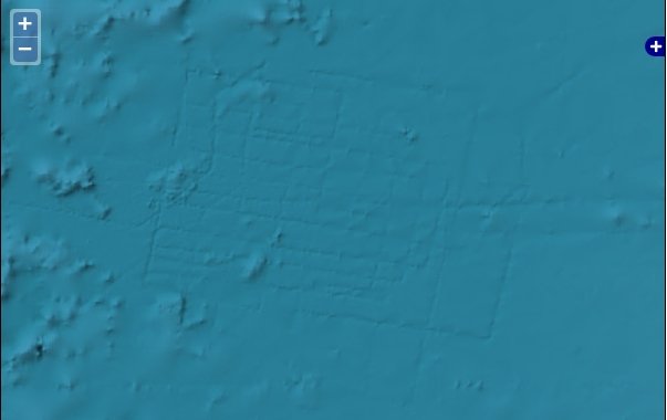
Jaye suggests in his various writings other bits of physical evidence, but with his apparently poor understanding of geology and geologic processes, they fall short of being useful. An example are photos of what he calls “fragment-created craters” on the coast of Argentina in the Santa Cruz province. In his MAA paper, Jaye writes in the caption, “the long axes of the larger craters measure several km, whereas the smaller craters are roughly one-tenth that size. Note the NNW-SSE orientation of the craters.”
Admittedly, the image does have that lunar-landscape feel to it. And the orientation of the craters is apparent. But they aren’t impact craters. They’re volcanic maars. A maar is a type of crater created when magma comes close to the crust, but there isn’t a violent eruption. Since he refers to his self-proclaimed impact craters as “as yet unrecognized by geologists,” it follows that Jaye has only his own expertise and methods to offer as the source of his assertion. When we look at the list of “ice craters” in table 1 of his paper, his ignorance in geologic method and theory becomes apparent. So much so, I urge Mediterranean Archaeology and Archaeometry to retract his paper as soon as possible.
Among his “ice crater” list, and just a few kilometers from craters shown in figure 3 of the MAA paper, is the Pali Aike Volcanic Field. “Aike” is a word that has several meanings in Tehuelche, the language of the indigenous people who are also called the Tehuelche. Among the meanings is “place” and there are several toponyms in Patagonia with “Aike” in the name: Aylen Aike (ember place), Pali Aike (devil’s place or devil’s country), Kosten Aike (place of the winds), and so on.
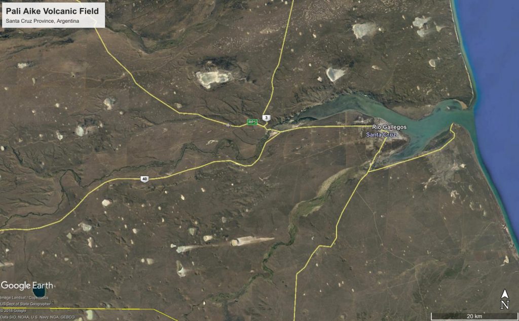
Jaye (2019) as impact craters. The are, in fact, volcanic and related to the
Pali Aike Volcanic Field shown in the center-bottom just under
Highway 40. Image courtesy of Google Earth.
The southern region of Argentina, from the Deseado Massif through the Magallanes Basin, is heavily mined for silver, gold, and many rare earth metals. Consequently, there is a large and growing body of research on the geology of the region readily available to anyone willing to look. The geologic history of the Pali Aike Volcanic Field is certainly understood well enough to distinguish the craters (often called lagunas and lagos by the locals since they frequently retain water) as volcanic rather than impact. I dare say, these actual researchers did more than stare at a Google Earth screen for a few minutes as they visited the locations, took core samples, produced topographic profiles from surface and seismic surveys, employed bathymetric instruments to the lakes, and determined the physical and chemical properties of the sediments in situ (Coronato, et al 2013; Zolitschka, et al 2006).
An Impact Event Caused a Worldwide Flood?
The conclusion Jaye seems to begin with is that there was a “worldwide flood.” Whatever that means. The Lemuria and Atlantis claims above, with the tangential stuff about the now-submerged river channels that are, in reality, just undersea channels formed by turbidity currents due to seafloor sediment movement, is all “proof,” in his mind, that the oceans were once absent. That 3 kilometers of seawater were added during this flood (though it is curious: how might he account for the fact that the Madeira Abyssal Plain—his “Atlantis”—sits at an average depth of 5.4 kilometers below the surface, which is nearly twice his seemingly arbitrary 3 kilometer depth?). The removal of this amount, he seems to suggest, was driven by the need to expose the “former river systems” that, as we now know were never terrestrial rivers at all.
What amount of water does one suppose this hypothetical comet would have to contain to raise sea levels by 3,000 meters? Jaye doesn’t say, which is disappointing since this is the one area I’d think his mathematics expertise might actually apply. In his MAA paper, he models the alleged comet. Well, he draws a picture and labels it with terms like “water ice,” “dust,” “minerals” and “solid core (iron, manganese, etc.).” I’m not sure this qualifies as a model when couched in scientific terms. Though I’m sure it does in Google-Earth-anomaly-hunter-researcher terms.
Full disclosure: I’m not a mathmagician. Not by any stretch of anyone’s imagination. My education is in archaeology and geology, however, so I know my way around a calculator (affectionately referred to in my office as the number figurin’ device).
The United States Geologic Survey (USGS) reports that the volume of water on earth is 1,386,000,000 cubic kilometers. About 71% of the Earth’s surface is covered by it. When we look at Jaye’s ArcGIS representation above, it’s pretty clear that he reduced it by more than half. I think we can all agree. So let’s be generous and just say 1/2 the amount. Which comes to 693,000,000 cubic kilometers of water. That would create a comet about 693 km in diameter. To put this in some perspective, the Chicxulub impactor is estimated to have been between 11 to 81 kilometers in diameter and having a mass of between 1.0×10^15 and 4.6×10^17 kg. The mass of a comet 693 km in diameter holding 693,000,000 cubic km of water would be roughly 6.93 X 10^20 kg.
This is all assuming I got the math right. Somebody peer review me and let me know. Like I said: not my area of expertise.
But in the mean time, this is not the sort of impact that leaves people arguing about whether nano-diamonds and spurious bits of platinum are evidence of an impact. It’s the kind of impact that doesn’t leave people. Or planets. If a comet that large impacted the planet with that much mass, you wouldn’t be reading this line at this moment.
Did comet or meteor impacts occur 12,800 years ago? Probably. There appears to be some good evidence that this is the case.
Did it contribute to the start of the Younger Dryas and the extinction of megafauna? I honestly don’t know the answer to that. But neither does Jaye by the look of things so far. I have a lot of questions that are shared by others when it comes to the YD impactor hypothesis. There’s little doubt that the pseudoscience crowd loves the idea. Sweatman, Collins, and others are quick to connect emerging discoveries to create sensationalist narratives with the Gobeckli Tepe-YD meteor/comet that is spurious at best. Wholesale fiction at worst. Hancock seems positively giddy and eagerly moved the goalposts of some of his conclusions around to fit new data as soon as they are published. Ancient, magical civilizations of Atlanteans and Lemurians roll off the pages of pseudoscientific books, sensationalist cable and YouTube channels, and click-bait websites, all marketed to the consumer.
These venues are bad enough. But to have journals like Mediterranean Archaeology and Archaeometry publish such rubbish without a modicum of fact-checking or peer-review is simply distasteful. And if the editors of MAA argue that fact-checking and proper refereeing occurred, they have a bigger problems.
I’m very tempted to submit a rebuttal to MAA just to see if they publish it. But I’d rather see pseudoscientific, cargo-cult-archaeology attempts like Jaye’s work be retracted.
Okay, now I can go read Rebecca Bradley’s article on this paper and see what I missed.
Sources and Further Reading
Coronato, Andrea, Bettina Ercolano, Hugo Corbella, and Pedro Tiberi (2013). Glacial, fluvial and volcanic landscape evolution in the Laguna Potrok Aike maar area, Southern Patagonia, Argentina. Quaternary Science Reviews, 71, 13-26.
Duin, Ed J.Th., C.S. Mesdag, and P.T.J. Kok (1984). Faulting in Madeira Abyssal Plain sediments. Marine Geology, 56(1-4), 299-308.
Jaye, Michael (2019). The Flooding of the Mediterranean Basin at the younger-Dryas Boundary. Mediterranean Archaeology and Archaeometry, 19(1), 71-83.
Jaye, Michael (2019). The Worldwide Flood [personal blog]. theworldwideflood.com [last accessed 11/15/2019].
Jaye, Michael (2017). The Worldwide Flood: Uncovering and Correcting the Most Profound Error in the History of Science. Bloomington, IN: Archway Publishing, 66 pages.
Kostic, Svetlana and Gary Parker (2006). The response of turbidity currents to a canyon–fan transition: internal hydraulic jumps and depositional signatures. Journal of Hydraulic Research, 44(5), 631-653.
Lebreiro, S.M., P.P.E. Weaver, and R.W. Howe (1998). Sedimentation on the Madeira Abyssal Plain: Eocene-Pleistocene History of Turbidite Infill. In P.P.E. Weaver, H.-U. Schmincke, J.V. Firth, and W. Duffield (Eds.), Proceedings of the Ocean Drilling Program, Scientific Results, Vol. 157(30), pp. 523-531.
Mulder, Thierry (2011). Gravity Processes and Deposits on Continental Slope, Rise and Abyssal Plains. Developments in Sedimentology, 25–148.
Nield, Ted (2009). Supercontinent: Ten Billion Years in the Life of Our Planet. Harvard University Press.
Richards, Robert J. (2008). The Tragic Sense of Life: Ernst Haeckel and the Sturggle over Evolutionary Thought. Chicago: University of Chicago Press.
Rothwell, R.G., B. Alibés, and P.P.E. Weaver (1998). Seismic Facies of the Madeira Abyssal Plain: A Correlation Between Seismic Reflection Profile and Borehole Data. In P.P.E. Weaver, H.-U. Schmincke, J.V. Firth, and W. Duffield (Eds.), Proceedings of the Ocean Drilling Program, Scientific Results, Vol. 157, pp. 473-498. (http://www-odp.tamu.edu/publications/157_SR/VOLUME/CHAP_28.PDF)
Scott-Elliot, Wm. (1904). The Lost Lemuria. https://www.hermetik-international.com/en/media-library/mysticism/william-scott-elliot-the-lost-lemuria/
Williams, S. R. J. (1987). Faulting in abyssal-plain sediments, Great Meteor East, Madeira Abyssal Plain. Geological Society, London, Special Publications, 31(1), 87–104.
Zolitschka, B., F. Schäbitz, A. Lücke, H. Corbella, et al (2006). Crater lakes of the Pali Aike Volcanic Field as key sites for paleoclimatic and paleoecological reconstructions in southern Patagonia, Argentina. Journal of South American Earth Sciences, 21(3), 294–309.
Madeira Abyssal Plain photo http://marineregions.org/mrgid/4616 (Marine Gazetteer Placedetails)
Baker Sea Channel photo MRGID http://marineregions.org/mrgid/6538 (Marine Gazetteer Placedetails)
USGS (2019). How Much Water is there On Earth? [last accessed: 11/17/2019]: https://www.usgs.gov/special-topic/water-science-school/science/how-much-water-there-earth?qt-science_center_objects=0#qt-science_center_objects
I took a quick look at the journal website. Doesn’t look like they are pay-to-play unless I missed some fine print about the $300 “processing fee”. But again I just took a quick look. Maybe just an example of a journal that plays fast and loose in terms of calling itself a peer reviewed journal.
Would love to see their response to a query about you writing a critical response to the article.
I wrote them about a month and a half ago. No response. I’m very tempted to submit a rebuttal, if only to see what’s involved in their acceptance practices.
No response is probably their response, then.
Maybe consider another outlet?
When I wrote them, I used their online contact form and was asking for comment. Specifically I asked:
I think since they probably have no desire to retract the article, somebody should at least write a rebuttal within the journal–assuming they’ll publish it.
This is also the same journal that Robert Schoch has published in along with the Sweatman pseudoscience about the Gobeckli Tepe / comet thing last year.
So you didn’t raise the issue of writing a commentary on the article but rather questioned the process by which it was published. I would suggest a follow-up message politely inquiring about writing a commentary on the article. If they don’t respond or refuse then take it elsewhere and send them a copy when it is published. Maybe give Public Archaeology a try. They have published stuff on the issue of pseudoarchaeology. Or Skeptical Inquirer.
I did actually close by saying I was writing for my blog and considering other venues like a journal or skeptical publication. I figure they either didn’t read my message through their contact form or chose not to respond.
If they are in the business of publishing stuff like this as well as stuff by the likes of Schoch and Sweatman it is probably not realistic to expect a rational response or any response at all. Like I said, if you are putting this much effort into it might as well try to get it in print somewhere.
Just keep the old mathematical formula in mind, though. You can shoot down in flames 9 out of 10 points that they try to make. But if they can even give the appearance of successfully contesting your criticism of #10 then they will hail it as a great victory.
All very true.
3,2,1….LOL
More of the old routine of “this happened here but a catastrophe wiped out any proof so you can’t prove that it didn’t happen.
Walter: for the Lost Civilization idea to really work, I’m of the opinion that several conditions would have to be met; 1.) It would have to be, relatively speaking, a very small civilization, something similar to Sumer or Ancient Egypt. 2.) the level of technology would have to be similar to either of the aforementioned societies. Otherwise, there should be at least *some* evidence remaining that even a large meteorite impact couldn’t completely erase, especially if that hypothetical civilization was worldwide and technologically sophisticated…
I don’t know that I have ever seen ancient Egypt referred to as very small. Maybe by relatively speaking you meant in comparison to somethng like the roman empire at its height or the Mongol empire, though?
Unless one was dealing with a something like a medieval Italian city state that took a direct hit from a huge comet the notion of being wiped out without a trace just doesn’t work. Even then you have to deal with the contradiction of a city state that was small enough to be totally obliterated but had a global impact, but didn’t leave an identifiable “footprint” in the archaeological record. The lack of an archaeological horizon is a consistent thumbs down when it comes to many pseudoarchaeology claims.
Walter: Modern Egypt is comparable in size to the state of Texas, and Ancient Egypt didn’t come close to covering that entire area, being mainly situated along the Nile River. So if you packed the entirety of Ancient Egypt into a single landmass, what would that encompass? Perhaps modern day Japan or England, or something smaller? I would say it would qualify as “small”, and under the right circumstances, easily obliterated by a major meteorite impact. By contrast, what would it take, impact wise, to wipe out every trace of our modern, world-wide, civilization? Unless the impactor was a “planet killer”, it would be nearly impossible. So, I think we are pretty much in agreement: the alleged “Lost Civilization” could not have been very large, global in extent, nor technologically sophisticated not to have left any trace at all in the archaeological record.
Normally papers like Jaye’s Worldwide Flood “paper” in MMA even if they somehow make it past peer-review, simply disappear into the literature by being ignored by serious scientists because of their numerous glaring defects. However, Jaye’s Worldwide Flood paper MMA is actually cited by presumably serious paper in a serious peer-reviewed journal, Journal of Coastal Research. The paper is:
Liritzis, I., Westra, A. and Miao, C., 2019. Disaster Geoarchaeology and Natural Cataclysms in World Cultural Evolution: An Overview. Journal of Coastal Research, 35(6), pp.1307-1330.
https://bioone.org/journals/Journal-of-Coastal-Research/volume-35/issue-6/JCOASTRES-D-19-00035.1/Disaster-Geoarchaeology-and-Natural-Cataclysms-in-World-Cultural-Evolution/10.2112/JCOASTRES-D-19-00035.1.short
It is curious that one of the coauthors of the above paper belongs to the Department of Mediterranean Studies, Lab. of Archaeometry and Lab. of Environmental Archaeology, University of the Aegean which also publishes MMA.
In another paper, Jaye’s Worldwide Flood “paper” is cited as having shown “…the remnants of the Young Dry-as impacting object found in the Southern Ocean, southeast of South Africa, north of Antarctica, and south of Madagascar…”
Again from the University of the Aegean, this paper is:
Oguz-K?rca, E.D. and Liritzis, I., 2019, Reemergence of Atlantis: The Shifting Paradigm and Creation of Neo-Spatial Models (Scientific Culture Vol. 5, No. 3, (2019), pp. 69-88
https://sci-cult.com/reemergence-of-atlantis-the-shifting-paradigm-and-creation-of-neo-spatial-models/
It is unfortunate that the time period for comments in the MMA has expired given the above attention given to Jaye’s Worldwide Flood “paper”.
So what actually needs to happen is this:
1.) We need a “Peer review of the Peer review” (some things you know, just slip through the cracks, and just aren’t seen during the first peer review).
2.) We need a list of what are “acceptable journals to publish in (this eliminates the need to actually read the offending article. If the journal doesn’t make the list, it’s defacto pseudoscientific).
3.) If any bloggers, or their acolytes, however obscure and regardless of credentials, sees stuff in a published, peer-reviewed paper they find objectionable, said paper should be immediately retracted or at the very least “black-balled”.
4.) All articles submitted for peer-review need to pass muster with some sort of Orwelllian Ministry of The Final Truth Board (to weed out racists, nazis and the deplorable folks).
5.) Also needed is a sort of “Pseudo-Science Detection Squad”; this august body could be composed of bloggers and be on call 24/7, even if roaming around the back woods of Kentucky looking for “metal detectorists” at odd hours of the night (hint, hint).
6.) And finally, those tatooed with the label of pseudo-scientist should not be able to use/cite a peer-reviewed paper in their published works (this gets very confusing when a pseudoscientist cites a non-pseudoscientist in the bibliography).
Gleaner63,
Some issues here. At its peak, Egypt stretched from the mouth of the Nile into northern Sudan. A long haul. Likewise from its westernmost outpost near or in present day Libya to its holdings at certain points almost to present day Turkey was a hell of a long way. Even if you just reduce it down to the original Egypt proper, which really wouldn’t make sense, you have a lot of area. Plenty of large nations or empires would not be so large if one could back it all together. The first British Empire would be much more modest if you discounted sparsely or unpopulated areas. Texas is really big. Not small for civilizations unless you are really doing some interesting number crunching.
Again, total obliteration might work for something like circa-1300 Venice, if one can suspend disbelief about the archaeological horizon. 700 miles north to south of all evidence of civilization being obliterated in a place like Egypt or anywhere else, nope.
Walter:
I used the example of Texas merely as something anyone could easily visualize. Of course, Texas is “large”, comparison wise, to say, South Carolina and Rhode Island. However, it is small in comparison to the landmasses of North and South America. Even if AE “stretched from the mouth of the Nile into Northern Sudan”, it’s not like it was one continuous, urban civilization. As anyone who’s ever driven through Texas can tell you, the are square miles of it which are sparsely or not inhabited at all. According to what I could find, population estimates of AE fall into the 2-5 million range, though no one is completely sure. A Chicxalub type event would more than likely have ended Ancient Egyptian civilization. Would it have completely obliterated it? What would it matter if most of the infrastructure was reduced to rubble? It would have been *effectively* destroyed. At any rate, what Graham Hancock seems to be describing is a world-wide civilization, something that could have easily survived a large meteorite impact. And of course, you are correct, there is as yet no “horizon” that gives us any evidence of that, so we are in agreement there…
Walter:
“…The Chicxulub impactor had an estimated diameter of 11–81 kilometres (6.8–50.3 mi), and delivered an estimated energy of 21–921 billion Hiroshima A-bombs (between 1.3 × 10 24 {\displaystyle 1.3\times 10^{24}} {\displaystyle 1.3\times 10^{24}} and 5.8 × 10 25 {\displaystyle 5.8\times 10^{25}} {\displaystyle 5.8\times 10^{25}} joules, or 1.3–58 yottajoules).[2] For comparison, this is ~100 million times the energy released by the Tsar Bomba, a thermonuclear device (“H-bomb”) that remains the most powerful man-made explosive ever detonated, which released 210 petajoules ( 2.1 × 10 17 {\displaystyle 2.1\times 10^{17}} {\displaystyle 2.1\times 10^{17}} joules, or 50 megatons TNT).[22] The impact created a hole 100 kilometres (62 mi) wide and 30 kilometres (19 mi) deep, leaving a crater mainly under the sea and covered by 600 metres (2,000 ft) of sediment by the 21st century.[23]…”.
An event of that size, you don’t believe that could have wiped out any civilization that existed on Earth in antiquity, especially something similar to Sumer or Egypt?
A lot of different people throw a lot of different numbers around about the estimated effects of an impact. Not sure of the relevance of an impact from 66 million years ago to this discussion.
There is a big difference between wiping out a large civilization and wiping out a large civilization without leaving a trace. Again, unless you are dealing with something massive scoring a direct hit on something like a city state limited entirely to a small area there will be some sort of remains in the archaeological record. Even that is very unlikely. Hancock is pitching a scenario where something big was there but a catastrophe destroyed all evidence of it. There is a difference between discussing total obliteration of a civilization with a presence over a great area and simply bringing a civilization to an end and leaving it in shambles.
Should also point out that recent research indicates that the Egyptian climate was significantly wetter than it is today up until about 1000BC. This would support small-scale agriculture and pastoralism in many areas that in the present would not be considered suitable at all for these activities. So, need to be cautious about looking at a contemporary physical environment and assuming that it is how things were 4000 years ago.
Walter states: “…A lot of different people throw a lot of different numbers around about the estimated effects of an impact. Not sure of the relevance of an impact from 66 million years ago to this discussion…”.
Simply put, of course the effects are “estimated”, because no one knows for sure exactly what would happen. After all, we can’t conduct a lab experiment under controlled conditions. However, most if not all would agree, that a modern “Chicxulub Event” would be catastrophic depending on several factors (the most important being the size of what it hit). Is there some reason you could suggest to believe it wouldn’t? As trivial as it may sound, an impact is an impact, regardless of the time frame (modern or 66 million years ago). I agree there’s a difference between bringing a civilization to end, merely leaving it in shambles, and obliterating all traces of it. And so again, the evidence for Hancock’s primary idea is lacking. As I’m sure you’re aware, NASA keeps a close eye on possible objects that might collide with the Earth; why do you think that is? If, as you seem to suggest, these objects are nothing more than a pain in the neck, then why look for them? Unless of course, a very large one, at the right time and place, might bring modern civilization to a grinding halt (or worse). Finally, I’m not quite sure the relevance of AE having a different climate thousands of years ago, perhaps you could explain further…
The following scenario seems reasonable: a “Chicxulub Event” would have brought the ancient Sumerian and Egyptian civilizations to an abrupt halt. An impact of that magnitude not only kills hundreds of thousands of people, it obliterates the physical infrastructure of those societies as well, meaning that megalithic architecture like the pyramids do not survive, and might not even survive as “fragments”. Further, no written records, even those in stone would survive. Even if contemporary civilization on the other side of the planet knew about Sumer and AE, that info would surely now fall squarely into the area of “legend”. It seems a given, a large enough impact event could have wiped out all traces of a high civilization in antiquity…