
Originally developed with a military purpose in mind, Unmanned Aerial Vehicles (UAVs) –also called “drones”– offer archaeologists an efficient advantage when it comes to archaeological survey in the field.
Most governments have provisions in place to protect their cultural resources as their countries grow and progress: laws to protect sites from looting, laws that ensure sites are explored before development, etc. Looters –those that would profit from the sale of unprovenanced antiquities ripped haphazardly from the ground– are clear enemies of archaeologists, who depend on the carefully documented contexts of artifacts and features, which provide priceless value in the story that can be told about a long-dead culture.
In Peru, where the economy has grown at an average of 6.5% each year over the last decade, progress is fast becoming a more dangerous threat than looters. Near Lima, a 5,000 year-old (est.) pyramid was destroyed by construction firms and pre-Incan ruins of Yanamarca were damaged by quartz miners. Progress happened before archaeologists could get there. The new enemy to archaeologists is time. Effective survey takes time. That’s where the drones come in.
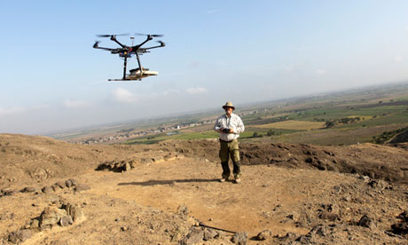
Two primary uses for drones so far seem to be monitoring and mapping. With a UAV, an archaeologist can set and monitor boundaries to sites as well as conduct mapping. Jaime Castillo, an archaeologist at the Lima Catholic University, said about mapping and survey, “with this technology, I was able to do in a few days what had taken me years to do.”
“It’s like having a scalpel instead of a club. You can control it to a very fine degree,” said Jeffrey Quilter, an archaeologist with Harvard University who has worked at San José de Moro and other sites in Peru. “You can go up three metres and photograph a room, 300 metres and photograph a site, or you can go up 3,000 metres and photograph the entire valley.”
Drone use in the U.S. has become something of a hot-button issue in the last few years, with some seeing them as a cause for alarm when it comes to safe-guarding privacy. Some states have even drafted legislation that prevents or restricts use and there is much talk of “shooting down” drones by private citizens. A town in Colorado has made laws and policy to protect anyone that shoots them down.
In Texas, my current home-state, the Texas Privacy Act (HB 912), sponsored by Republican Rep. Lance Gooden, would make it illegal to take photographs or possess photographs taken from UAVs. On the cuff, this looks like it might be good legislation to protect the average person from nosy UAV owners that want to post embarrassing photos or videos on YouTube, but when you look closely it severely favors businesses or government entities that wish to operate illegally.
In the Dallas-Fort Worth area, a hobbyist piloting a small UAV took aerial photos of the Columbia Packing Company’s illegal dumping of pig blood into the Trinity River. This was a gross violation of law in 2011 that was reported by a hobbyist. And officials acted within minutes.
Aerial reconnaissance is not a new idea to archaeologists. We’ve been using kites, scaffolds, planes, helicopters, gigapan, and even satellites. But drones, or UAVs, will offer a flexibility and control that none of these can provide, allowing the gap of time between archaeological survey and progress to be closed significantly.
Related articles


Leave a Reply
You must be logged in to post a comment.