
If you missed Part 1, go here first!
A Few of the Core Claims
What follows are the claims of the Bosnian pyramid crowd, much of which was found on www.bosnianpyramids.org, Osmanagic’s website. The claims are paraphrased for clarity and brevity and quotations are used around exact wording of the original claim.
The hills (Visocica, Plješevica, and Bu?ki) present an equilateral triangle. “Each side of the triangle measures approx 2,170m (with the margin of error being less than 2%) and the inside angles of the triangle each measure 60 degrees.”
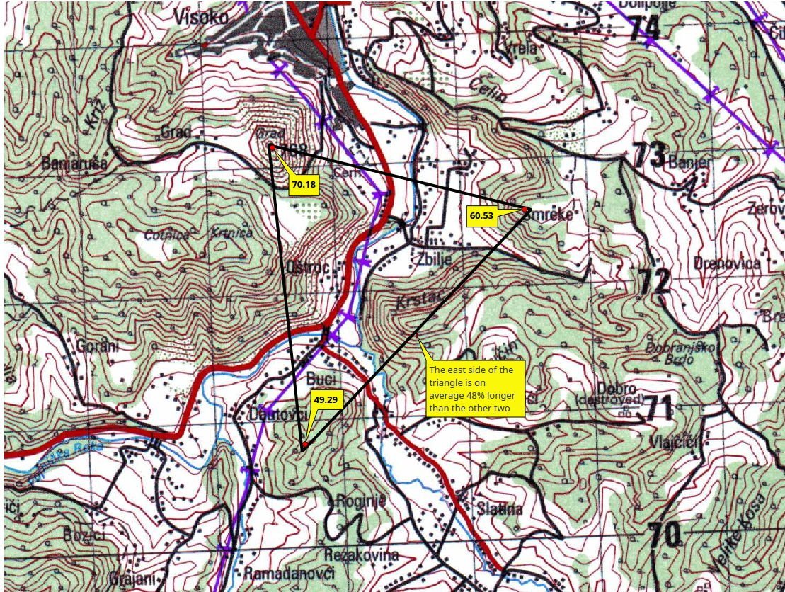
This is actually partially true. If one draws a line from each of the hilltops to another and then closes the loop, a triangle is formed. One of the angles—the northeast one—is 60.53 degrees. The other two angles, however, are 49.29 (northwest) and 70.18 (south). This was measured after placing the vertices on their respective hilltops. I’m fairly certain I placed the Visocica and Plješevica points to within a few meters of the apexes of their respective hills. However, the Bu?ki hill is more of a ridgeline than a discrete hill. So placing the point was a bit more arbitrary. But the ridge is a few hundred meters long and is angled somewhat toward Plješevica. But not so long that it should have had such a profound effect on the other two angles or the length of the sides. The north side of the triangle measures approximately 2,000 meters hilltop to hilltop. However—and this is a big however—the southeast side of the triangle was on average 48% longer than the other two sides.
The triangle formed by the hilltops is certainly not equilateral nor are all the sides equal at 2,170 meters in length. Ostensibly, this claim is intended to show how some sort of intent was at play to build structures rather than the happenstance of geology, the forces of which are less likely to be so precise. It may be possible to fudge the data by pushing the locations of the triangle’s vertices a little here and there, but one would have to then account for why there’s a higher point above a vertex when other vertices are at hilltops, why choose the back of a hilltop rather than the front like other vertices, and so on. This sort of pattern-seeking is rather meaningless, even if one were to have a perfect triangle with equilateral sides and angles that perfectly adopted the hilltops, this exercise could doubtlessly be replicated in many places around the world with many shapes. To grant special significance here is to grant it everywhere, rendering the practice meaningless.
Another spurious connection that pyramid proponents have made with Visocica Hill is that it is allegedly aligned to the cardinal directions. That is to say, the sides of the hill are at the north, south, east, and west. Coincidentally, this is almost true, but not quite. The geologic feature that creates a triangular face on the north side of the hill is, coincidentally, facing the north. But does this imply that it is man made? To answer that, lets look at the two aspects of the claim that create the coincidence. First, there’s the triangular face of the hill. If we accept that a triangular hill-face equals human creation, then we should not find natural explanations. Yet we find naturally created, triangular faces on hills and mountains all over the world with regularity. At East Mountain, near Huntington, Utah is a ridge that has several such hills. And more than one of these face a cardinal direction (west)! These particular hills are called faceted spurs and are the result of faulting. They’re often, but not always, created in chains along the fault line and ridge. In the case of the facet at Visocica Hill, the uplift of the anticline and the small fault worked to create the faceted spur that has come to be seen as pyramid-shaped. An anticline is an uplifted or folded section of layered rock, the opposite of a syncline, which is also a folded section of layered rock, but in a trough rather than a crest. The two are most often interleaved, very much like waves. These folds, or “waves” in the landscape, typically occur over millions of years as the earth’s crust compresses and moves as a result of sea-floor spreading. Occasionally, other tectonic forces like faulting work with the forces of erosion and weathering to remove sections of the anticline, exposing the underlying layers and, in the process, creating some sharply dipped slopes. Slopes like Visocica Hill.
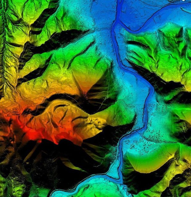
Visocica Hill is the result of orogenic uplift, thrust faulting, and erosion which have left behind a faceted spur that almost (but not precisely) faces true north. The remaining “faces” of this alleged pyramid don’t resemble a pyramid at all. In the LIDAR image, there is but a single triangular facet. And, if you look close at the LIDAR image of the Visoko region, at least two more eroded faceted-spurs can be discerned across the river from Visocica Hill to the east, also facing somewhat north.
The construction of the pyramids includes concrete blocks or stone tiles “cut into megaliths of different dimensions which are characteristic of pyramid construction.”.
Except there is no good reason to believe these are “cut” at all. And every reason to believe that they are naturally deposited sedimentary layers of rock. There are three primary formations that are said to be man-made by the pyramid proponents. 1) the mudstone layer with visible ripple marks from a Miocene lake bottom; 2) a heavily jointed and fractured sandstone layer; and 3) a conglomerate layer claimed to be “concrete.”
The region of Visoko used to be a lake during the Miocene epoch, about 23-5 million years ago. As it perhaps dried and became shallow, the slight wave action created a rippled silt and sand bottom that later became a layer of sedimentary rock, overlying other sedimentary rock layers, and overlain with still other layers of sedimentary rock. During the millions of years since the lake dried, the anticline was formed by tectonic forces that created the folds and hills we see today.
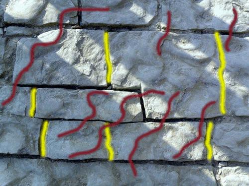
When one looks closely at the mudstone with ripples, you can see that the ripples continue from one “block” to the next. Would Osmanagic have us all believe that these blocks were quarried somewhere, transported some unknown distance, then reset in exactly the same order they were carefully quarried from? So careful, I might add, that none were apparently broken in either removal or resetting since all the ripples perfectly match!
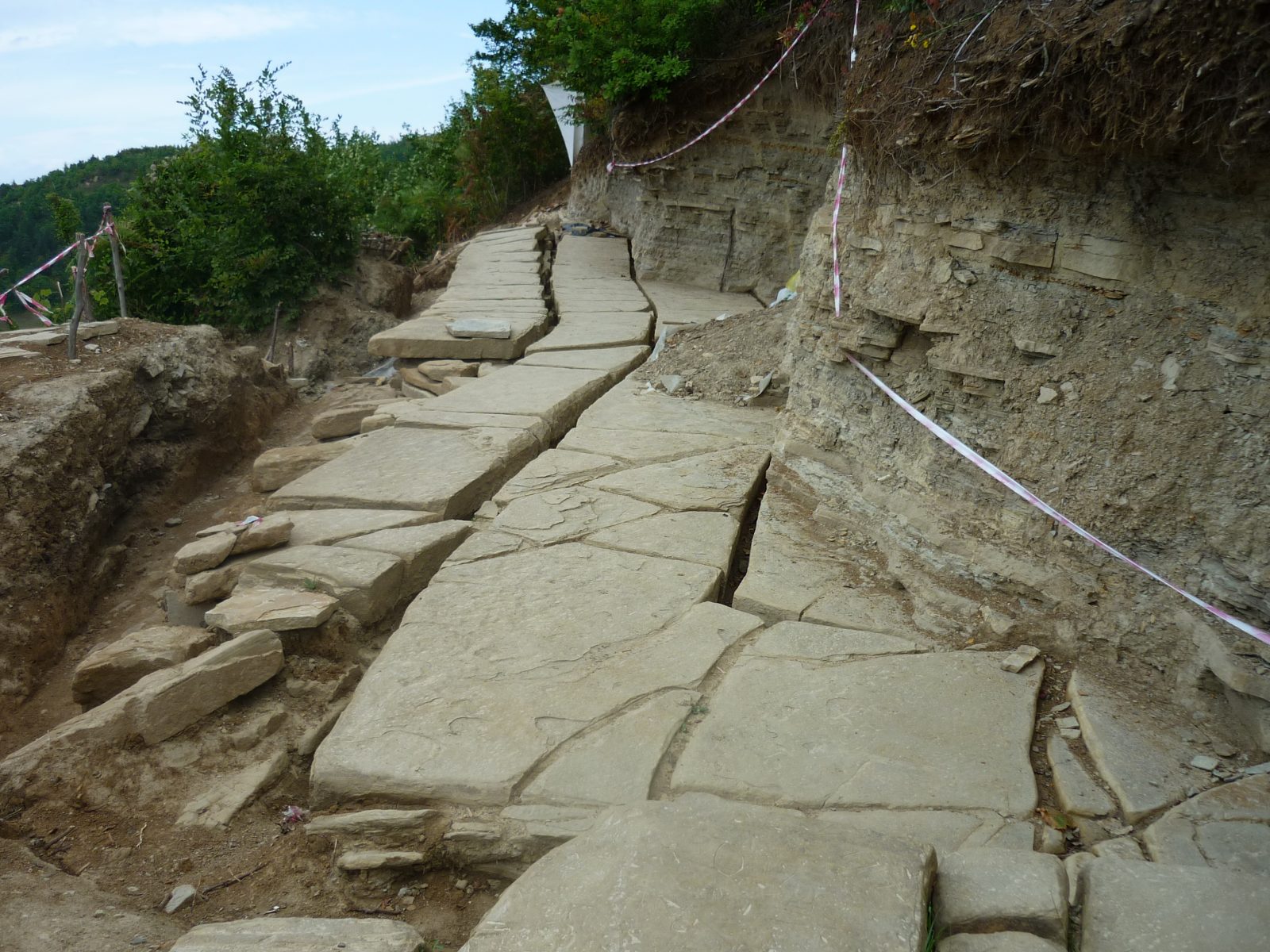
The heavily jointed sandstone creates the look of very large blocks, but again, this is a very natural formation. No where are tool marks present from the quarrying. Such tool marks are readily visible on the stone blocks quarried for pyramids in Egypt. Moreover, they in a geologic formation where such jointing and fracturing is expected. This is not an unknown or little understood process among geologists.
The alleged “poured concrete” likewise a natural conglomerate of pebbled conglomerate or stone breccia within a carbonate-based matrix. Make no mistake, this is a concrete, albeit one that is formed by nature. Natural concretes like conglomerates and breccias can be much softer or more brittle than man-made ones, but they can also be much, much harder. They’re formed in sedimentary layers over millions of years as a result of the natural sorting and consolidation of their components: pebbles, cobbles, and even boulders within a finer matrix of sand, silt, or clay. Over time, calcium carbonate or an oxide creates a chemical hardening of the mix, in much the same way we create concrete for modern construction. Again, this is not a little understood process and it is common throughout the world, including Bosnia.
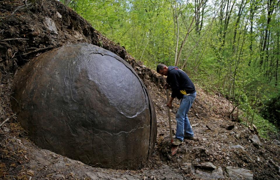
Large stone spheres are proof of advanced technology among the people who built the pyramids and are 1,200 – 1,300 years ago based on ceramic remains found with one or more of the spheres.
A common feature in sedimentary rock formations is that of the concretion, particularly the carbonate variety. Quartz can form concretions as well, through a microcrystalline process, to form chert nodules. Most concretions, however, are carbonate, such as iron-carbonate, sandstone concretions, and mudstone concretions. The process of formation for all is much the same. First, there is an initial precipitation. That is to say, some bit of matter appears in a matrix of that causes a chemical reaction. Perhaps it’s some acidic water that begins to eat away at the carbonate grains of sediment or a deceased organism that begins to decay which sets off a chain of chemical events.
Geologists call the process diagenesis, which is the changing of sedimentary rock into another sedimentary rock at temperatures and pressures that are much less than that required for the creation of metamorphic rocks. Sedimentary rocks, you might know, are created when layers of sediment are deposited either slowly or quickly over time. This can be sediment that precipitates, or falls out of, water such as in a lake or sea, or it can be sediment that drops out of the winds on dry land, such as with a sandstorm. Sediment can also be formed by decaying organic material in both water and on land. Planktons can die off and fall to the sea floor and trees drop leaves and cover the forest floor. They all decay and leave behind carbonate grains of sediment which can result in many meters thick layers of rock over millions of years. Metamorphic rocks are created through heat and pressure on sedimentary rocks (or igneous rocks, which are a result of volcanic activity). Marble is an example of a metamorphic rock created from limestone. You can sometimes see the deformed remnants of fossils within marble that were in the original limestone, a sedimentary rock usually created from the skeletal fragments of marine organisms in seas or oceans. With the pressures of tectonic movement and the heat of nearby magma deep while deep underground, a metamorphosis takes place over time, transforming the limestone into the marble we use for counter-tops and tombstones today.
Diagenesis, however, doesn’t require the heat and pressure needed for a metamorphic transformation. But this process won’t produce marble from limestone either. Instead, concretions begin, often very soon after deposition of the sediment, as a chemical change within the sediment itself. As the sediment layer increases, so, too, does the weight of the sediment above, squeezing out the water held in suspension in the spaces between the grains of sediment. As this happens, a mineral precipitates from the remaining pore water and, if conditions are right, a cementing process can begin in the resulting chemistry. This is the point at which the concretion has nucleated or created a center for itself. From here, the chemical process continues over time, and the concretion grows outward. In some sediments the growth might result in a squashed or ovoid appearance. In others, say a very pure sand of mostly spherical and equally sized grains, the resulting concretion will be more spherical. This is because the conditions (grain size, permeability, etc.) imposed are roughly equal in all directions. In mud-stones, the clay matrix makes it preferable for the concretion to grow slightly more horizontally than vertically, thus the resulting squashed or ovoid appearance.
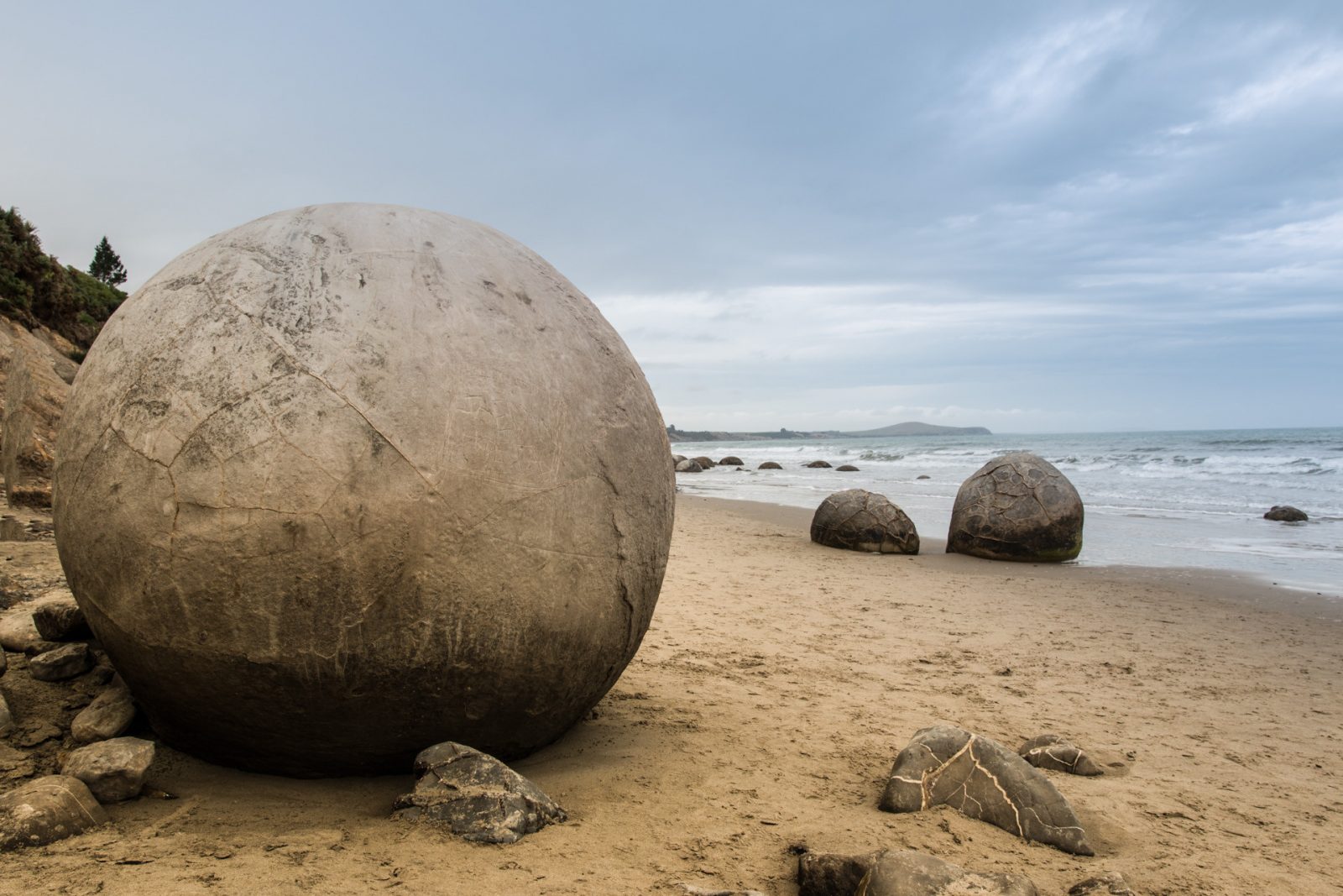
In sediments of fine or very small grain sizes, concretions can grow to be very large, many as large as 3 meters across. On the beach of South Island, New Zealand, concretions known as the Moeraki Boulders have weathered out of a mudstone layer that are in just under 3 meters in diameter. In northern California, there’s a beach aptly named “Bowling Ball Beach” that has spherical and ovoid concretions that are also weathered from a mudstone formation. These are much smaller examples than their Moeraki cousins, but many are considerably larger than bowling balls!
And there are concretions in Bosnia, not far from Visoko. Osmanagic described them as being high in iron content due to their brown and red coloration. While he sees this as evidence of being man-made, iron-rich concretions even at this size, which was at least 3 meters in diameter for many of them, are not uncommon. Hydrated iron sulfates or hydroxides have been known to form concretions around an iron center or nucleation and can grow quite large over time into spherical formations. This isn’t just theoretical. Scientists studying Mars created concretions from iron-sulfate and iron-hydroxide in a laboratory. They wanted to see if they could duplicate what they were seeing on the Martian surface, and determine what factors influenced what outcomes (pH, changes in solution chemistry, motion, etc.). But the concretion spheres in Bosnia aren’t even spheres according to geologists who have visited the site. Robert Schoch, a noted geologist that sometimes takes the side of so-called alternative views and sometimes takes the side of “mainstream” views about geofacts that relate to the human past, found no reason to conclude that these were man-made objects. In fact, descriptions of the stones by those that accompanied him were of the mudstone variety as they weren’t spherical at all, rather they were somewhat elliptical and had the texture of slate or shale. It’s important to note that the geologic formations in the region of Visoko are sandstone and mudstone.
But, even had these concretions turned out to be man-made, it isn’t clear from Osmanagic how they would be associated with his alleged “pyramid.”
Pay No Attention to the Man Behind the Curtain?
Osmanagic creates the illusion of man-made features by modifying the terrain himself. He clears the topsides of rock layers like the mudstones and limestons in the photographs. Overlooked are the fact that these features continue into the walls of natural rock layers. Look above or below in some of the photos and you will see some of the same sorts of layers. But the most significance difference between Osmanagic’s efforts and what you would see at a real archaeological excavation are answers to some key questions: where are the quarries? Where did the workers who created the structure sleep? Where are the tool marks?
In none of the “sites” Osmanagic has “excavated,” will you find… sites. We see natural geology that is claimed to be man-made. But we see not the inscriptions, the living spaces needed to support a workforce on the grand scale he suggests. We see not the quarries that vast amounts of stone and concrete are removed from. At Cairo in Egypt, the quarries still have stones ready to be moved, and the blocks—left in the quarry as well as on the pyramids—show signs of tooling. In Cahokia, the largest man-made earthen mound north of Mexico, borrow pits for the dirt are still visible on the landscape even today. In both Cairo and Cahokia, living spaces for the people who constructed these monuments have been located, excavated, and documented with thousands of artifacts cataloged and hundreds of features recorded at each.
In Visoka, neither quarry nor construction camp has been found. Nor should it be since there is simply no good reason to accept that this is a set of “pyramids” rather than a set of hills that have mulitiple sites from multiple periods of history within them. Sites that are in grave danger due to Osmanagic’s efforts.
Conclusions
The “Bosnian Pyramid” claim is stark example of pseudoscience as it is applied to the world of archaeology—a true pseudoarchaeological claim. But it’s also a claim with a nationalist archaeology point of view. In a nation where an appeal for unity and a need to counter the many divisions that once fueled a savage and recent war, something like a grandiose pyramid—possibly the largest, oldest in the world—might be the very thing to bolster the pride and patriotism among a populace as it regains its economic strength and place in a world that grows smaller and closer by the day. Tourist income alone probably feeds and cloths many within the region of Visoko, and they can hardly be blamed for wanting to be proud of something or to feel important. The unfortunate reality, however, is that Osmanagic and his team are using the Bosnian people for personal gain at the probable expense of losing their real heritage, which may be obliterated by bulldozers and excavators as they create the fake remnants of a non-existent culture.
Further reading
Bai, T., Maerten, L., Gross, M. R., and Aydin, A., (2002). Orthogonal cross joints: Do they imply a regional stress rotation? Journal of Structural Geology. vol. 24, pp. 77-88.
Harding, A (2007). “The Great Bosnian Pyramid Scheme.” British Archaeology, 92.
IRNA (2006). “Geology of the Bosnian Pyramids.” Le site d’Irna. IRNA, 25 Nov. 2006. http://irna.lautre.net/Geology-of-the-Bosnian-pyramids.html
Jerram, Dougal and Chapman, Henry (2012) Ancient X-Filess02e09. National Geographic Channel. http://www.nationalgeographic.com.au/tv/ancient-x-files/episodes.aspx?series=2
Müller,Johannes; Knut Rassmann und Zilka Kujundži?-Vejzagi? (2013). “Okolište – Rekonstruktion spätneolithischer und frühchalkolithischer Siedlungsprozesse des zentralbosnischen Visokobeckens: Fragestellungen, Forschungsstrategien, Ergebnisse.” In J. Müller, K. Rassmann, R. Hofmann (Eds.), Okolište – Untersuchungen einer spätneolithischen Siedlungskammer in Zentralbosnien. Bonn: Universitätsforschungen zur prähistorischen Archäologie pp. 207–229.
Rose, M. (2009) “The Bosnia-Atlantis Connection.” Archaeology, February http://www.archaeology.org/online/features/osmanagic/
Schoch, R. “The Bosnian Pyramid Phenomenon.” The New Archaeology Review. 1 Sep. 2006, Volume 1, Issue 8: 16-17.
Woodard, C. (2009) “The Mystery of Bosnia’s Ancient Pyramids.” Smithsonian Magazine. Smithsonian Institution, December http://www.smithsonianmag.com/history-archaeology/The-Mystery-of-Bosnias-Ancient-Pyramids.html
Leave a Reply
You must be logged in to post a comment.